Back to the on-screen lesson ·
Coordinates mean something only within a system and datum; degrees of latitude are about 111 kilometers, degrees of longitude shrink toward the poles, and grids give distances by Pythagoras.
Paper packet. Every task here also exists on screen, where it is checked automatically; answers written on paper are not assessed by Nydus. When you are back at a device, enter your answers there.
By the end of this lesson you will be able to turn coordinates into distances, compute distances on a grid, and explain why the same place can have different coordinates.
You know latitude and longitude from earlier geography, and six-figure grid references from physical geography. This lesson treats coordinates as data: numbers whose meaning depends on the system they belong to, and which can be turned into distances.
| Term | What it means |
|---|---|
| Latitude | An angle north or south of the equator, from 0 to 90 degrees. |
| Longitude | An angle east or west of the prime meridian, from 0 to 180 degrees. |
| Datum | The model of the Earth's size, shape and origin that coordinates are measured on. |
| Projection | A method of flattening the curved Earth onto a map. |
| UTM | The Universal Transverse Mercator grid of meters east and north within zones. |
| Easting and northing | A point's distance east and north on a projected grid. |
A coordinate pair only has meaning inside its reference system.
Another way: picture
Picture giving directions from a landmark: three blocks north of the old courthouse. If a new courthouse is built and someone measures from that instead, the same house gets a new description. A datum is the landmark coordinates are measured from, and changing it changes the numbers without moving anything.
Another way: steps
Inspect coordinates and metadata before changing anything. A longitude such as minus 104 and an easting such as 420000 use different units and origins; they are not directly comparable. Even two projected layers in meters can use different zones or datums. Confirm the axis order, units, projection, datum and, where supplied, coordinate epoch. An on-screen overlay may already be reprojected by software, so apparent alignment is not proof that stored coordinates share a CRS.
Assigning a CRS changes the interpretation of existing numbers. Transforming a layer computes coordinates in a target system using the verified source system and transformation. If the source is unknown, investigate its provenance rather than assigning whichever label looks right. Preserve an original copy, record the operation and test identifiable control locations distributed across the study area. Avoid fitting points visually to the boundaries you hope to study: that uses the desired result as a calibration target.
A reservoir boundary and inspection points disagree at surveyed control posts. First rule out swapped axes and incorrect units using the metadata. The files name different datums. Make a transformed copy of the inspections using a documented operation appropriate to the region. Three control posts then agree within the stated survey tolerance. This supports the reference-system diagnosis at those posts; it does not prove every point is accurate. Test additional posts across the area and record residual offsets. Only then combine the layers. If one isolated inspection still disagrees while others align, investigate its collection or digitizing history rather than shifting the entire layer again.
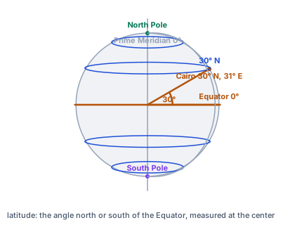
A latitude is not a distance up a map; it is an angle measured at the center of a model of the Earth. On the globe, one line runs from the center to Cairo and another to the equator directly south of it, and the 30 degrees between them are Cairo's latitude. Every place on the 30 degrees north ring makes the same angle, so a parallel is a circle.
A degree of latitude is nearly the same length everywhere; a degree of longitude shrinks toward the poles.
| Latitude | One degree of latitude | One degree of longitude |
|---|---|---|
| 0° (equator) | 111 km | 111 km |
| 30° | 111 km | 96 km |
| 45° | 111 km | 78.5 km |
| 60° | 111 km | 56 km |
In miles, a degree of latitude is about $69$; in nautical miles, approximately $60$. A nautical mile is exactly 1852 meters, so the angular conversion is approximate and varies with latitude on an ellipsoid.
The Earth is not a perfect sphere; it bulges at the equator. A datum fixes a model of its shape and ties it to the ground. The North American Datum of 1927 was based on surveys anchored at a ranch in Kansas; the North American Datum of 1983 was fitted to the whole Earth with satellite measurements.
The same survey marker has different coordinates in the two datums, differing by tens of meters in much of the country and more than a hundred in places.
Combining data from different datums without converting them places features in the wrong spot. A road digitized in one datum and a property line in another may appear to cross when they do not.
Older U.S. Geological Survey maps used the 1927 datum; GPS receivers default to a modern one. A hiker plotting GPS coordinates on an old map, without matching datums, can be off by the length of a football field.
The Universal Transverse Mercator system divides the world into sixty zones, each six degrees of longitude wide, and gives every point an easting and northing in meters within its zone.
Because eastings and northings are in meters and at right angles, the distance between two points is simply $\sqrt{\Delta E^2 + \Delta N^2}$. Points $600$ m apart in easting and $800$ m in northing are $1000$ m apart.
Many American states and counties use state plane coordinate systems, with zones drawn to fit each state so that distortion stays very small. Surveyors, engineers and county offices use them for property records and construction.
Several western states have borders drawn along parallels of latitude by Congress in the nineteenth century, when the land was surveyed across open plains. Colorado runs from 37 to 41 degrees north, and Wyoming from 41 to 45.
Four degrees of latitude is about $444$ km, which gives each of those states its north-south extent, whatever its width.
Coordinates written with many decimal places look precise, but precision is not accuracy. A position to six decimal places of a degree is written to about ten centimeters, yet it may be tens of meters off if the datum is wrong or the GPS reading was poor.
Good metadata states the datum, the method and the expected accuracy, not only the numbers.
Checking an answer. A straight distance must be at least as long as either leg and no longer than their sum. A degree of longitude can never exceed $111$ km.
Multiplying by 111 is allowed because the Earth's circumference is about $40000$ km, and dividing by $360$ degrees gives about $111$ km per degree along a meridian. Multiplying by the cosine for longitude is allowed because parallels are circles whose radius shrinks by the cosine of the latitude.
Using Pythagoras on a grid is allowed because eastings and northings are at right angles on the flat projected map.
A GPS receiver computes its position from satellite signals and reports it in a chosen system, usually latitude and longitude on a modern datum. Phones do the same, blending in Wi-Fi and cell towers. Emergency dispatchers and search teams rely on all parties agreeing on the system.
The most common slip is treating a degree as a fixed distance for longitude, forgetting that it shrinks toward the poles. Another is using $69$ or $60$ when kilometers are wanted.
A third is adding the easting and northing differences instead of using Pythagoras. A fourth is combining coordinates from different datums as if they matched.
In a GIS, every feature carries coordinates, and every analysis, from measuring distances to overlaying layers, depends on them matching. The next unit builds on this: layers can only be overlaid when they share a coordinate system.
For most of the twentieth century, American maps used the North American Datum of 1927, built from surveys tied to a station at Meades Ranch in Kansas. In 1986 the National Geodetic Survey released the North American Datum of 1983, fitted to the whole Earth using satellite measurements.
Switching datums shifted the coordinates of every point in the country, by tens of meters in much of the lower forty-eight states and more than a hundred in parts of the West and Alaska, without anything on the ground moving. Maps, surveys and databases had to be converted, and many older U.S. Geological Survey maps still print both sets of grid ticks.
The National Geodetic Survey is now replacing even the 1983 datum with a newer reference frame, because the continent itself drifts a couple of centimeters a year and modern GPS can measure it.
When Congress organized the western territories in the nineteenth century, it often drew their borders along lines of latitude and longitude rather than rivers or ridges, which were poorly mapped. Colorado's borders run along 37 and 41 degrees north and along meridians, making it nearly a rectangle.
Surveyors marked those borders on the ground with stone monuments, working across open plains and mountains with the instruments of the time. Some of their lines strayed from the true parallels by hundreds of meters, and the surveyed lines, not the intended ones, became the legal borders.
With four degrees of latitude between its borders, Colorado stretches about 444 kilometers north to south. Its east-west width, measured in degrees of longitude, is larger in degrees but shrinks in kilometers compared with a state the same width near the equator.
It is natural to think a place has one true set of coordinates, so that two different sets mean one is wrong. But coordinates are measured in a system, on a datum, and the same place has different numbers in different systems, all correct.
Trouble comes from mixing systems without converting, and from treating degrees as fixed distances: a degree of longitude shrinks toward the poles, while a degree of latitude stays about 111 kilometers.
Two towns on one meridian are $3$ degrees of latitude apart. Recall a degree.
$111\ \text{km}$
Along a meridian.
Multiply the degrees by it.
$3 \times 111 = 333\ \text{km}$
North to south.
Convert to miles for comparison.
$3 \times 69 = 207\ \text{mi}$
Miles per degree.
Name the slip to avoid.
$207 \text{ km}$
Mixing miles and kilometers.
Find the cosine of $60$ degrees.
$\cos 60° = 0.5$
Half.
Multiply by $111$.
$111 \times 0.5 = 55.5\ \text{km}$
Per degree at 60 degrees.
Find the distance across $4$ degrees there.
$4 \times 55.5 = 222\ \text{km}$
Along the parallel.
Compare with the equator.
$4 \times 111 = 444\ \text{km}$
Twice as far.
Say why it halves.
$\text{meridians converge}$
Toward the poles.
A marker is at easting $500000$, northing $4200000$ in one datum. In another it is at $500060$, $4200080$. Find the shift east.
$500060 - 500000 = 60\ \text{m}$
Meters.
Find the shift north.
$4200080 - 4200000 = 80\ \text{m}$
Meters.
Square and add.
$60^2 + 80^2 = 10000$
Pythagoras.
Take the square root.
$\sqrt{10000} = 100\ \text{m}$
The straight shift.
Say whether the marker moved.
$\text{no}$
Only its coordinates changed.
Say what to do before combining data.
$\text{convert to one datum}$
Or features misalign.
Square and add the differences.
$900^2 + 1200^2 = 2250000$
Pythagoras.
Take the square root.
$1500\ \text{m}$
The straight distance.
Check against the legs.
Two towns lie on the same meridian, $1.5$ degrees of latitude apart. About how far apart are they, in kilometers?
Complete the worked solution: a survey marker is at easting $301000$ and northing $4455000$ in an older datum, and at easting $301018$ and northing $4455024$ in a newer one. Find the shift east, the shift north, and the straight distance between the two positions, in meters.
Find the shift east.
$\text{new easting} - \text{old easting} =$ e
Meters.
Find the shift north.
$\text{new northing} - \text{old northing} =$ n
Meters.
Find the straight shift.
$\sqrt{\text{east}^2 + \text{north}^2} =$ s
Meters.
Say what a mismatch would do.
$\text{misplace a point by that much}$
Mixing datums on one map.
Match each coordinate term to its meaning.
| an angle north or south of the equator | an angle east or west of the prime meridian | the model of the Earth's size, shape and origin | a method of flattening the curved Earth onto a map | |
|---|---|---|---|---|
| latitude | ||||
| longitude | ||||
| datum | ||||
| projection |
A degree of longitude spans about $111$ km at the equator times the cosine of the latitude. Fill in its length, to the nearest kilometer, at the equator, at 30 degrees and at 60 degrees.
| length | |
|---|---|
| at the equator (km per degree) | |
| at 30 degrees (km per degree) | |
| at 60 degrees (km per degree) |
Along a certain parallel, one degree of longitude spans about $96.1$ km. Write the distance east, in kilometers, as a function of the degrees of longitude $x$.
Answer:
Two points in one UTM zone differ by $900$ m in easting and $1200$ m in northing. How far apart are they in a straight line, in meters?
Answer: m
Colorado's southern border follows the parallel at $37$ degrees north and its northern border the parallel at $41$ degrees north. About how far is it from its southern border to its northern border, in kilometers?
Answer: unit: m / km
Mark the supported observation, provenance requirement and spatial limit in this fictional wildlife audit. Points were displaced and metadata recorded different datums. After a documented transformation, 3 independent markers agree within tolerance. No wildlife observation was repeated.
This task has no paper form; do it on a device.
Lesson test: one question per skill, one attempt each, no hints. Your answers are checked when you submit.
Along a certain parallel, one degree of longitude spans about $96.1$ km. Write the distance east, in kilometers, as a function of the degrees of longitude $x$.
Answer:
You can reason about coordinates. Explain why a survey marker can have two sets of coordinates that are both correct.
26. Your turn: two points differ by $900$ m in easting and $1200$ m in northing. How far apart are they?, step 3
$1200 < 1500 < 2100$
Longer than either, shorter than both.