Rainforest, desert, temperate forest, taiga and tundra: why the world's great biomes lie in belts, and how to read one from its climate figures.
Paper packet. Every task here also exists on screen, where it is checked automatically; answers written on paper are not assessed by Nydus. When you are back at a device, enter your answers there.
1. What you will learn
You will read real climate graphs and figures, name the biome a place is in from how hot and how wet it is, and explain why the deserts and rainforests lie where they do.
2. What you already know
You know latitude, and that places near the Equator are hot all year. You know that rising air cools and gives rain. Put those together and you can already explain much of where the world's forests and deserts are.
3. Words for this lesson
Term
What it means
Weather
What the air is doing at one place on one day.
Climate
The average weather of a place over about thirty years.
Biome
A very large area whose plants and animals are adapted to one kind of climate.
Adaptation
A feature that helps a living thing survive where it lives.
Monsoon
A season of very heavy rain brought by a change in the wind.
Temperature range
The warmest month's average minus the coldest month's.
4. Climate decides what can live where
Two numbers describe most of a climate: how hot and how wet. Plants need warmth and water, so wherever those two numbers are alike, the same kind of plants grow, and the same kinds of animals live among them. That is a biome.
Near the Equator, strong sunshine heats the ground, warm air rises and it rains almost every day: tropical rainforest, as around Manaus in Brazil. At about 20 to 30 degrees north and south, that air sinks again, and sinking air is dry: hot deserts, such as the Sahara and the deserts of Arizona. Farther from the Equator, summers are warm and winters cool, and rain falls in every season: temperate forest, as in much of the eastern United States. Farther still, winters are long and bitter: taiga, the conifer forest of Canada and Alaska. Nearest the Poles, summer is too short and cold for trees: tundra.
Another way: diagram
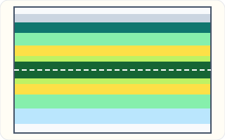
A simplified sketch, not a map: colored belts running across a rectangle from the top, which is the far north, to the bottom, which is the far south. A dashed line runs across the middle. From the top down: a white belt, a pale gray belt, a dark teal belt, a light green belt, a yellow belt, a narrow yellow-green belt, then a wide dark green belt across the middle. Below the middle: a narrow yellow-green belt, a yellow belt, a light green belt, a pale blue belt and a white belt at the bottom.
A simplified sketch of the belts: dark green rainforest across the Equator, yellow desert belts either side, then light green temperate forest, dark teal taiga and gray tundra toward the north. Real biomes are patchier, broken up by mountains, seas and winds.
Another way: steps
To name a biome from its figures: 1. Is it hot all year, or does it have a cold season? 2. Is it wet, or does it get very little rain? 3. If it is cold, is the summer long and warm enough for trees?
5. Compare water across seasons
Two places can have similar warmth but different plant communities if their water supplies differ. Year-round moisture supports plants that cannot survive a long dry season. Where streams dry seasonally, plants may shed leaves, store water or reach deeper moisture. Compare rainfall timing with river behavior rather than reading temperature alone. A biome describes broad ecological patterns; a farm, irrigated park or cleared hillside may differ from surrounding vegetation. A climate map therefore does not prove which crops people grow or how they earn a living. Look for land-use evidence as well.
6. Reading a climate graph
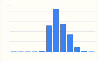
A column graph with twelve columns, one for each month from January on the left to December on the right. Faint lines across the graph are 200 mm apart. The first five columns are so short they are almost flat. The sixth rises to about 520 mm, the seventh is the tallest at about 850 mm, the eighth is about 550 mm and the ninth about 340 mm. The tenth is about 90 mm, and the eleventh and twelfth are almost flat again.
This is Mumbai's average rainfall, month by month, January on the left. Mumbai is hot all year, but almost all its rain comes in the monsoon, from June to September, and July alone brings about 850 mm. A graph like this shows what a single yearly total hides: when the rain comes.
Place
Coldest month
Warmest month
Rain in a year
Manaus
about 26 °C
about 28 °C
about 2,300 mm
Cairo
about 14 °C
about 28 °C
under 30 mm
London
about 6 °C
about 19 °C
about 600 mm
Yakutsk
about minus 39 °C
about 19 °C
about 240 mm
7. Weather is not climate
Weather changes by the hour: a sunny morning, a stormy afternoon. Climate is the pattern those days make over about thirty years: how warm the summers usually are, how much rain usually falls, and when.
The National Weather Service publishes climate normals for thousands of American towns, each an average over thirty years. A biome is matched to those normals, not to any single day, however unusual.
8. Why rainforests are wet
Near the Equator the Sun is high all year, so the ground heats strongly. Warm, moist air rises, cools and drops its water, often in afternoon thunderstorms almost every day.
So the rainforest is wet because it is hot, not hot because it is wet. The heat and water together let plants grow all year, which is why rainforests hold more kinds of plants and animals than any other biome.
9. Why deserts lie in belts
The air that rises at the Equator spreads out high up and sinks back down at about $20$ to $30$ degrees north and south. Sinking air warms and dries, so the land beneath it gets very little rain.
That is why the world's great hot deserts, the Sahara, the Arabian, the Kalahari and the Australian deserts, lie in two belts. The deserts of the American Southwest sit near the northern belt too, around $32°$ N.
10. Temperate forests
Between the deserts and the cold north lie the temperate forests, with warm summers, cool or cold winters and rain in every season. Oaks, maples and hickories drop their leaves in fall and grow new ones in spring.
Much of the eastern United States, from Georgia to New England, was once temperate forest. Its fall colors come from the trees shutting down for a winter too cold to grow in.
11. Taiga and tundra
The taiga, also called the boreal forest, stretches across Alaska, Canada, Scandinavia and Russia. Its winters are long and bitter, but its summers are warm enough for spruce, fir and pine, whose needles shed snow and survive the cold.
North of the taiga, the tundra's summer is too short and cool for trees. The ground below the surface stays frozen all year, and only mosses, grasses and low shrubs grow.
12. Temperature range
The yearly temperature range is the warmest month's average minus the coldest month's. Places near the sea have small ranges, because water warms and cools slowly. Places far inland, such as Yakutsk in Siberia, have huge ranges.
When the coldest month is below zero, subtracting it adds its size. From $-39$ to $19$ is $39$ degrees up to zero and $19$ more, a range of $58$ degrees.
13. The method, step by step, and how to check it
How hot? Hot all year, or a cold season?
How wet? Plenty of rain, or very little?
If cold, how warm is summer? Warm enough for trees, or not?
Name the biome, then check its plants fit.
Checking an answer. A range is never negative. A hot desert gets very little rain even if it is sometimes cold at night.
14. Why each step is allowed
Plants need warmth to grow and water to live, so the two numbers, heat and rain, decide which plants can survive in a place. Where the plants are alike, the animals that eat them are alike too, which is what makes a biome.
Averaging over thirty years is allowed because it smooths out unusual years. A biome grows over centuries, so it matches the long average, not the extremes.
15. Adaptations
Living things in each biome have features that suit its climate. A saguaro cactus stores water in its stem; a desert tortoise digs burrows to escape the heat. Spruce trees have narrow needles that lose little water in frozen winters.
Adaptations help explain why plants and animals from one biome often struggle in another. A saguaro would freeze in Alaska, and a spruce would wilt in the Sonoran Desert.
16. Mountains make their own belts
Climbing a mountain is a little like traveling toward the Poles, because the air gets colder with height. On a tall mountain in Arizona or Colorado you can pass from desert at the bottom through forest to bare tundra-like slopes near the top.
That is why biome maps are patchier than the simple belts. Mountains, seas and winds break up the pattern that latitude alone would draw.
17. Common slips
The most common slip is naming a biome from one day's weather instead of the long average. Another is thinking all deserts are hot; Antarctica is the largest desert on Earth, and it is frozen.
A third is subtracting a below-zero temperature the wrong way and getting a range that is too small. A fourth is thinking the rainforest is hot because it is wet, when it is wet because it is hot.
18. In the world: the Sonoran Desert's two rainy seasons
Tucson and Phoenix sit in the Sonoran Desert of Arizona, where rain is scarce, often under a foot in a whole year. Yet the Sonoran is one of the greenest deserts on Earth, crowded with saguaros, palo verde trees and wildflowers.
Its secret is timing. It gets two rainy seasons: gentle winter rains from Pacific storms and violent summer storms from the North American monsoon, when moist air flows north from the Gulf of California and the Gulf of Mexico in July and August. A climate graph for Tucson shows two humps where most deserts show one or none.
The saguaro is built for this pattern. Its shallow roots soak up a summer storm in hours, and its pleated stem swells like an accordion to store the water for the dry months. Reading when the rain comes, not just how much, explains why the Sonoran holds life that other deserts cannot.
19. In the world: from taiga to tundra in Alaska
A drive north through Alaska crosses two biomes. Around Fairbanks, in the interior, the land is covered in taiga: spruce, birch and aspen. Winters are long and fiercely cold, often far below zero Fahrenheit, but summers bring long, warm days that let the trees grow.
Farther north, past the Brooks Range, the trees thin out and stop. On the North Slope around Utqiagvik, the northernmost town in the United States, the July average is only a few degrees above freezing. The summer is too short and cool for trees, and the ground beneath stays frozen all year: tundra.
The line where the trees stop, called the tree line, follows the warmth of summer. Scientists are watching it closely, because as Alaska warms, shrubs and trees are spreading north into the tundra, showing how biomes shift when climate changes.
20. Where this goes wrong
A biome is defined by today's weather. It is defined by climate, the average over many years. Snow fell on the Sahara's edge in 2018, and it is still a hot desert.
All deserts are hot. A desert is a place with very little rain. Antarctica is the largest desert of all, and it is frozen.
The rainforest is hot because it is wet. It is wet because it is hot: the heat makes air rise, and rising air brings rain.
21. Which biome is Manaus in?
Manaus is about 26 to 28 °C in every month. Judge the heat.
$\text{hot all year}$
No cold season.
It gets about 2,300 mm of rain a year. Judge the wet.
$\text{very wet}$
Plenty of rain.
Combine the two answers.
$\text{hot and wet}$
Both numbers together.
Name the biome.
$\text{tropical rainforest}$
The Amazon.
22. Why is the taiga not tundra?
Yakutsk's winter is about minus 39 °C. Judge the winter.
$\text{bitterly cold}$
Colder than most tundra.
Its July is about 19 °C. Judge the summer.
$\text{warm enough for trees}$
Conifers can grow.
Find the range.
$19 - (-39) = 58$
A huge swing.
Name the biome.
$\text{taiga}$
The warm season decides it.
Compare with tundra.
$\text{summer too cold for trees}$
A few degrees above freezing.
23. How much of a year's rain is the monsoon?
A city gets $300$, $700$, $500$ and $300$ mm in June to September. Add them.
$300 + 700 + 500 + 300 = 1800$
The monsoon months.
The year brings $2250$ mm. Find the share.
$\dfrac{1800}{2250} \times 100 = 80\%$
Part over whole.
Find the rest of the year.
$2250 - 1800 = 450\ \text{mm}$
Eight drier months.
Judge the heat and the wet.
$\text{hot, very wet in summer}$
A monsoon climate.
Say what the yearly total hides.
$\text{a long dry season}$
Only a graph by month shows it.
Say why it matters to farmers.
$\text{crops need water in the dry months}$
Timing, not just the total.
24. Your turn: Cairo
Judge Cairo's heat.
$14 \text{ to } 28\ °\text{C}$
Hot, with a mild winter.
Judge Cairo's rain.
$\text{under 30 mm a year}$
Almost none.
Your turn: work this step out. Its working is at the end of the packet.
Name the biome.
25. Guided practice
Match each biome to its climate.
long, very cold winters and short warm summers
hot and wet all year round
cold most of the year, with a short cool summer
hot days and very little rain
tropical rainforest
hot desert
taiga
tundra
26. Guided practice
Complete the worked solution: a monsoon city gets $250$ mm of rain in June, $500$ mm in July, $350$ mm in August and $100$ mm in September, and $1600$ mm in the whole year. Find the rain in those four months, their percent of the year's rain, and the rain in the other eight months.
Add the four wet-season months.
$\text{June} + \text{July} + \text{August} + \text{September} =$ m
The monsoon's rain.
Find their share of the year.
$\dfrac{\text{monsoon}}{\text{year}} \times 100 =$ p
Percent of all the rain.
Find the rest of the year.
$\text{year} - \text{monsoon} =$ r
Eight drier months.
Say what a yearly total hides.
$\text{when the rain comes}$
A graph by month shows it.
27. Guided practice
The saguaro cactus of the Sonoran Desert in Arizona has a thick, waxy stem that swells after rain, spines instead of leaves, and roots that spread wide just under the surface. Which biome is it adapted to, and why?
Tropical rainforest, because it needs lots of rain to swell up.
Hot desert, because it stores water and loses very little.
Tundra, because the spines keep it warm.
Any biome, because plants grow wherever they are planted.
28. Guided practice
In January 2018 snow fell on the sand dunes near Ain Sefra, a town in Algeria on the edge of the Sahara. A student says the Sahara can no longer be called a hot desert. Are they right?
Yes. Snow proves it is really a cold desert now.
No. A biome is set by the climate over many years, not by one day's weather.
Yes. Any place where it has ever snowed is a cold biome.
No, because it can never snow in a desert.
29. Guided practice
This graph shows Mumbai's average rainfall for each month, from January on the left to December on the right. Click the column for the **wettest** month.
This task has no paper form; do it on a device.
30. Practice
London's average temperatures, rounded, for four months of the year (1991 to 2020): January $6$ °C, April $10$ °C, July $19$ °C and October $12$ °C. Plot these four points, with the month number along the bottom (January is 1) and the temperature up the side.
Plot your answer on the grid:
31. Practice
Here are rounded long-term climate figures for five real places. Name the biome each one is in.
Biome
Manaus, Brazil: about 27 °C all year; about 2,300 mm of rain a year
Cairo, Egypt: 14 °C in January, 28 °C in July; under 30 mm of rain a year
London, UK: 6 °C in January, 19 °C in July; about 600 mm of rain a year
Yakutsk, Russia: minus 39 °C in January, 19 °C in July
Utqiagvik, Alaska: minus 25 °C in January, 5 °C in July
32. Practice
This simplified sketch shows the world's biome belts from the far north at the top to the far south at the bottom; the dashed line is the Equator. Yellow stands for hot desert. Click **every** belt where hot deserts are most common.
This task has no paper form; do it on a device.
33. Practice
Yakutsk, in Siberia, is one of the coldest cities on Earth. Its average January temperature is about $-39$ °C and its average July temperature is about $19$ °C. What is its yearly temperature range, in °C?
Answer:
34. Somewhere new
Two unfamiliar lowland places have equally warm temperatures. For 2 decades, place A has had rain every month and a river that flows all year. Place B has a long dry season and streams that dry up.
Read the field-note analysis below. Select the temperature comparison and water observation needed to explain the contrast, AND the inference that leaves room for human land use. Leave unsupported claims unmarked.
This task has no paper form; do it on a device.
35. Lesson test
Lesson test: one question per skill, one attempt each, no hints. Your answers are checked when you submit.
36. Test question
For an invented temperate place, the coldest month's mean temperature is 2 degrees Celsius and the warmest month's mean is 16 degrees Celsius. What is the annual range between these monthly means, in degrees Celsius?
Answer:
37. What you can do now
You can read a climate and name its biome. Tell somebody the difference between weather and climate, and why a snowy day did not change the Sahara. Next: people, and where on Earth they choose to live.