Back to the on-screen lesson ·
Two angles that fix any place on Earth: how far north or south of the Equator, and how far east or west of the Prime Meridian.
Paper packet. Every task here also exists on screen, where it is checked automatically; answers written on paper are not assessed by Nydus. When you are back at a device, enter your answers there.
You will find and describe real places with latitude and longitude: which number comes first, what each letter means, and how to turn degrees of latitude into kilometers and miles.
On a town map with a grid you named a square with two numbers: along the bottom first, then up the side. The whole Earth has a grid too. It is drawn on a ball instead of a flat sheet, and its numbers are angles called degrees.
| Term | What it means |
|---|---|
| Equator | The imaginary line around the middle of the Earth, halfway between the Poles; latitude $0°$. |
| Latitude | How far north or south of the Equator a place is, in degrees from $0°$ to $90°$. |
| Prime Meridian | The line from Pole to Pole through Greenwich, England; longitude $0°$. |
| Longitude | How far east or west of the Prime Meridian a place is, in degrees from $0°$ to $180°$. |
| Degree | A unit of angle, written with a small circle: $30°$. |
| Parallel | A line of latitude; every one runs around the Earth parallel to the Equator. |
| Meridian | A line of longitude, running from the North Pole to the South Pole. |
Lines of latitude run around the Earth like hoops, all parallel to the Equator. The Equator is $0°$. Going north, the numbers rise to $90° N$ at the North Pole; going south, they rise to $90° S$ at the South Pole. So latitude can never be more than $90$.
Lines of longitude run from Pole to Pole like the segments of an orange. The Prime Meridian is $0°$, and the numbers rise to $180°$ going east or going west, meeting on the far side of the world.
A position is written latitude first: Denver, Colorado, is at about $40° N$, $105° W$. The letters matter as much as the numbers, because $40° N$ and $40° S$ are more than 8,000 km apart.
Another way: steps
Another way: story
A sailor in the middle of the ocean has no street signs. Measuring the angle of the Sun at noon tells her the latitude; an accurate clock tells her the longitude. With the two numbers she can find her dot on the chart, exactly as you will find dots on the grid below.
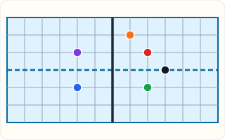
This grid has no land on it, only lines. The dashed line is the Equator and the thick line is the Prime Meridian. The lines are $30°$ apart, so one line above the dashed line is $30° N$ and two lines to the right of the thick line is $60° E$.
Some real cities, rounded to whole degrees:
| City | Latitude | Longitude |
|---|---|---|
| Anchorage, Alaska | 61° N | 150° W |
| Miami, Florida | 26° N | 80° W |
| Singapore | 1° N | 104° E |
| Buenos Aires, Argentina | 35° S | 58° W |
Singapore is almost on the Equator and is hot all year. Anchorage is two-thirds of the way to the North Pole, and its winter days are short and dark.
Two numbers in the wrong order name a completely different place. So everyone who uses coordinates, from pilots to phone maps, agrees on one order: latitude, then longitude.
On a town grid you said across first. On the Earth you say up or down first. The habit is worth practicing, because swapping the numbers is the most common slip of all: $30° N$, $60° E$ is in the Middle East, while $60° N$, $30° E$ is in Russia.
Imagine a line from the center of the Earth to your town, and another from the center to the Equator directly south of it. The angle between those two lines is your latitude.
That is why latitude is measured in degrees, not miles. Every place on the same parallel makes the same angle, so all of them share one latitude, whether they are in Oregon, Maine or the middle of the Atlantic Ocean.
Because the Earth is almost a sphere, each degree of latitude covers about the same ground everywhere: about $111$ kilometers, or $69$ miles. To turn a difference in latitude into a distance north or south, multiply the degrees by $111$ for kilometers or by $69$ for miles.
Denver, at $40° N$, is about $40 \times 69 = 2760$ miles north of the Equator. Keep the angle and the distance apart until the last step, then convert.
When two places are on the same side of the Equator, subtract their latitudes to find how far apart they are. Chicago at $42° N$ and Miami at $26° N$ are $16°$ apart.
When one is north and one is south, the Equator lies between them, so add. A town at $10° N$ and one at $5° S$ are $15°$ apart, not $5°$. Checking the letters first tells you whether to add or subtract.
Longitude is tied to time. The Earth turns $360°$ in $24$ hours, which is $15°$ an hour. That is why time zones are roughly $15°$ of longitude wide.
New York, near $74° W$, is about five hours behind London, near $0°$, because it is about $75°$ farther west. Before radio, sailors found their longitude by comparing the local time of noon with the time on a clock set to Greenwich.
Checking an answer. A latitude is never more than $90$ and a longitude never more than $180$. A position without its letters is incomplete.
Latitude and longitude are defined as angles from two fixed lines, the Equator and the Prime Meridian, so any place has exactly one pair of numbers once those lines are agreed.
Converting degrees of latitude to distance is allowed because the parallels are evenly spaced on a sphere. Degrees of longitude are not: the meridians meet at the Poles, so a degree of longitude is $111$ km at the Equator and shrinks to nothing at a Pole.
The Equator splits the Earth into the Northern and Southern Hemispheres. The Prime Meridian and the line opposite it split it into the Eastern and Western Hemispheres.
The whole United States is in the Northern and Western Hemispheres, so every American city has an N and a W in its position. Australia is in the Southern and Eastern Hemispheres, so its cities carry an S and an E.
The Equator is set by nature, halfway between the Poles. The Prime Meridian is not; any meridian could have been zero. In 1884 an international conference in Washington, D.C., chose the one through the Royal Observatory at Greenwich, near London.
Most of the world's sea charts already used Greenwich, which is why it was picked. It shows that some parts of a coordinate system are nature and some are agreement.
A phone's map uses latitude and longitude, usually written as decimals: the Washington Monument is at about $38.89° N$, $77.04° W$. Some apps write south and west as negative numbers instead of letters, so $-77.04$ means $77.04° W$.
Satellites of the Global Positioning System let the phone work out its own coordinates to within a few meters, which is how it can show you as a dot on the map.
Latitude does more than name a place: it helps explain its climate. Near the Equator the Sun is high all year and it is hot. Toward the Poles the Sun is lower and the winters longer and colder.
That is why Miami, at $26° N$, has warm winters and Anchorage, at $61° N$, has snowy ones. Later lessons in this course use latitude to explain the pattern of climates and biomes across the world.
The most common slip is swapping latitude and longitude. Another is dropping the letters, which leaves a position that could be in any of four places.
A third is reading degrees as kilometers or miles: $45° N$ does not mean 45 of anything on the ground. A fourth is subtracting latitudes across the Equator, when one north and one south must be added.
Search and rescue teams in national parks such as Yellowstone and Grand Canyon work by coordinates. A lost hiker who calls for help with a phone can read out a position like $44.46° N$, $110.83° W$, and a helicopter crew can fly straight to it.
The order matters. If a caller reads the numbers the other way around, $110.83$ first, the position makes no sense, because a latitude can never be more than $90$. Dispatchers are trained to ask for latitude first and to check the letters, since a missing W would put the hiker on the other side of the world.
Rescue teams also turn degrees into distance. Each hundredth of a degree of latitude is about $1.1$ kilometers, so two readings a few hundredths apart tell a crew how far a hiker has walked since the last call. The same arithmetic you practice here, degrees times $111$, guides a real search.
Much of the border between the United States and Canada, from Minnesota's Lake of the Woods west to the Pacific coast, follows a single line of latitude: $49° N$. Treaties in 1818 and 1846 set it there, so a line on the globe became a line on the ground.
Because it is a parallel, every point on that stretch of border is the same distance from the Equator: about $49 \times 111 = 5439$ kilometers, or $49 \times 69 = 3381$ miles. Surveyors in the 1800s marked it with iron and stone posts, and a strip of cleared forest still shows it from the air.
The border shows both halves of a coordinate. The latitude stays fixed along the whole line, while the longitude changes from about $95° W$ at Lake of the Woods to about $123° W$ near the Pacific. Following a parallel means holding one number steady and letting the other change.
Latitude is not a distance east or west. It is the north-south number, and a good way to remember it is that lines of latitude lie flat, like the rungs of a ladder you climb north or south.
Degrees are not kilometers. $45° N$ does not mean 45 km from anything. It means an angle, which works out at about 5,000 km of ground.
Swapping the two numbers gives a completely different place, just as it did with grid squares. $30° N$, $60° E$ is in the Middle East; $60° N$, $30° E$ is in Russia, near St. Petersburg.
Its position is $35° S$, $58° W$. Split it in two.
$35° \text{ S} \mid 58° \text{ W}$
Latitude, then longitude.
Read the latitude.
$35° \text{ south of the Equator}$
A little over a third of the way to the South Pole.
Read the longitude.
$58° \text{ west of the Prime Meridian}$
In the Western Hemisphere.
Name its hemispheres.
$\text{Southern and Western}$
From the two letters.
Chicago is at $42° N$ and Miami at $26° N$, close to the same meridian. Check the sides.
$\text{both north}$
The same side of the Equator.
Subtract the latitudes.
$42 - 26 = 16°$
Same side means subtract.
Convert to miles.
$16 \times 69 = 1104\ \text{miles}$
About 69 miles a degree.
Convert to kilometers.
$16 \times 111 = 1776\ \text{km}$
About 111 km a degree.
Check the size.
$\text{about a two-hour flight}$
A sensible distance.
Cairo is at $30° N$ and Nairobi at $1° S$, not far from the same meridian. Check the sides.
$\text{north and south}$
Opposite sides.
Add the latitudes.
$30 + 1 = 31°$
The Equator lies between them.
Convert to kilometers.
$31 \times 111 = 3441\ \text{km}$
About 111 km a degree.
Convert to miles.
$31 \times 69 = 2139\ \text{miles}$
About 69 miles a degree.
Check what subtracting would give.
$30 - 1 = 29$
Wrong: that treats both as north.
State the answer with its limit.
$\text{about 3,400 km, north to south}$
Only the north-south part of the trip.
Read the first number.
$34° \text{ S}$
The latitude: south of the Equator.
Read the second number.
$151° \text{ E}$
The longitude: east of the Prime Meridian.
Name the hemispheres.
On this grid the dashed line is the Equator and the thick line is the Prime Meridian. North is up the page and east is to the right, and the lines are 30° apart. Click the dot at **30° N, 60° E**.
This task has no paper form; do it on a device.
Complete the worked solution: town P is at $17°$ N and town Q is at $31°$ S, on the same line of longitude. Find how many degrees of latitude apart they are, and about how far that is in kilometers and in miles.
Add the two latitudes.
$\text{north} + \text{south} =$ t
The Equator is between them.
Turn degrees into kilometers.
$\text{degrees} \times 111 =$ k
About 111 km in each degree.
Turn degrees into miles.
$\text{degrees} \times 69 =$ m
About 69 miles in each degree.
Check the two distances agree.
$\text{kilometers} \approx 1.6 \times \text{miles}$
A mile is about 1.6 km.
A pilot plans a trip that visits five real cities in order from the farthest north to the farthest south. Put them in that order: Buenos Aires ($35° S$), Reykjavik ($64° N$), Singapore ($1° N$), Lima ($12° S$) and Cairo ($30° N$).
Number the steps in order (write the number in the box):
A ship radios its position as **45° N, 20° W**. What does the part *45° N* tell you about where the ship is?
New Orleans, a city near the mouth of the Mississippi River, is at about $30°$ north, $90°$ west. This line runs from $0°$ at the Equator to $90°$ at a Pole. Put the marker at how far New Orleans is from the Equator.
0 |——————————| 90
Mark the position with a cross, then write the value:
A map of an imaginary ocean, drawn with lines of latitude and longitude 30° apart. The thicker line across the middle is the Equator and the thicker line up the middle is the Prime Meridian; north is up and east is to the right. A weather buoy is at 30° N, 90° E, and a research ship is at 30° S, 90° W. Put both on the map.
This task has no paper form; do it on a device.
Four real cities and their positions, rounded to whole degrees. For each one, say which side of the Equator it is on and which side of the Prime Meridian.
| North or south of the Equator? | East or west of the Prime Meridian? | |
|---|---|---|
| Sydney: 34° S, 151° E | ||
| Reykjavik: 64° N, 22° W | ||
| Lima: 12° S, 77° W | ||
| Tokyo: 36° N, 140° E |
Town P is at $33° N$ and town Q is at $6° S$, and both are on the same line of longitude. How many degrees of latitude apart are they?
Answer:
Buenos Aires, the capital of Argentina, is at about $35°$ south. Each degree of latitude is about $111$ km of ground. About how far is Buenos Aires from the Equator, measured straight south?
Answer: unit: m / km
On a globe, an invented research station lies 12 degrees south of the Equator and 89 degrees east of the prime meridian. A report lists latitude first and longitude second. Which record locates it correctly?
Lesson test: one question per skill, one attempt each, no hints. Your answers are checked when you submit.
Reykjavik, the capital of Iceland, is at about $64°$ north. Each degree of latitude is about $111$ km of ground. About how far is Reykjavik from the Equator, measured straight north?
Answer: unit: m / km
You can fix a place with two numbers. Tell somebody which one comes first, and why $30° N$ and $30° S$ are nowhere near each other. Next: why every flat map of the world gets something wrong.
24. Your turn: where is Sydney, at 34° S, 151° E?, step 3
$\text{Southern and Eastern}$
From the letters.