Another way: diagram
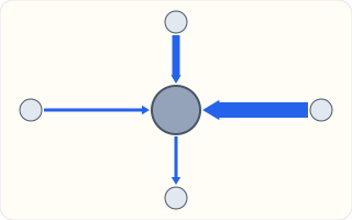
Morning journeys between a city and four towns. The very thick arrow from the right shows a large flow into the city; the thin arrow from the city down to the bottom town shows a small flow going the other way.
Back to the on-screen lesson ·
Commuting, migration, trade and tourism: the flows that join places, the links they travel along, and how to read a flow map honestly.
Paper packet. Every task here also exists on screen, where it is checked automatically; answers written on paper are not assessed by Nydus. When you are back at a device, enter your answers there.
You will trace a flow from origin to destination along its link, read a flow map's arrows and thicknesses, and explain what happens when a link changes.
You have seen that people travel into cities for work and services, and that ports such as Long Beach send goods on across the country. Those journeys join places together. This lesson gives you the words and the maps for them.
| Term | What it means |
|---|---|
| Flow | A movement of people, goods or information from one place to another. |
| Origin | The place a flow starts. |
| Destination | The place a flow ends. |
| Link | What a flow travels along: a road, railroad, shipping lane, canal, pipeline or cable. |
| Flow map | A map that shows flows with arrows, often thicker for bigger flows. |
| Supply chain | The chain of steps that brings a product from where it is made to where it is used. |
Every morning millions of people commute into cities and every evening they go home. Some people migrate, moving to live somewhere else for good; others travel as tourists. Goods are traded: Brazil sends coffee to the United States, and the United States sends airplanes and machines to Brazil. Each of these is a flow with an origin, a destination and a link.
Links shape flows. When the Panama Canal opened in 1914, the sea voyage from New York to San Francisco shrank from about 14,000 miles around the tip of South America to about 6,000 miles, and trade between the two coasts grew.
A flow map uses arrows, because a flow has a direction, and often shows the amount by the thickness of the arrow or by a number beside it. A plain line between two places shows only that they are linked.
Another way: diagram
Morning journeys between a city and four towns. The very thick arrow from the right shows a large flow into the city; the thin arrow from the city down to the bottom town shows a small flow going the other way.
Another way: steps
To describe a flow: 1. What is moving: people, goods or information? 2. From where (origin) to where (destination)? 3. Along what link? 4. How much, and does it change with the time of day or year?
A growing town may sit where several routes meet, even if nearby land has similar soil or rainfall. Follow a good from its production place to the buyer: field, loading point, railway, port, market. Then ask which work and services might draw people toward the connecting places. In an invented example, a new bridge gives a quarry access to a market; houses appear near the bridge while a similar valley without a crossing grows slowly. This supports an access explanation, but does not prove every resident works in the quarry. Compare opening dates, job records and other changes before claiming a cause.
| Kind | What moves | Example |
|---|---|---|
| Commuting | people, daily, to work or school | a nurse taking the train into the city |
| Migration | people, to live somewhere new | a family moving from Mexico to Texas |
| Trade | goods | coffee from Brazil, phones from China |
| Tourism | people, for a vacation | a week on a beach in Florida |
Flows usually come in pairs going opposite ways. Coffee goes from Brazil to the United States and money goes back. Commuters go into the city in the morning and out in the evening.
Commuting is the daily flow of people to work or school and back. In most big American cities the morning flow runs into downtown and the evening flow runs out, which is why highways jam in one direction at a time.
Trains carry huge commuter flows in a few cities. Each weekday, hundreds of thousands of people arrive in Manhattan through Penn Station and Grand Central alone, from New Jersey, Long Island and the suburbs to the north.
Migration moves people for good. Some migrate from one country to another; many more move within a country, from one state or city to another, for jobs, family or a lower cost of living.
A migration flow changes both places: the origin loses people and the destination gains them. The Great Migration of the 1900s, when millions of Black Americans moved from the South to Northern cities, reshaped both regions.
Trade moves goods from where they are made to where they are used, often through many steps. A sack of coffee travels from a Brazilian farm to a port, across the sea, to a roaster and finally to a cafe.
That chain of steps is a supply chain. Each link must work for the goods to arrive: a strike at a port, a storm at sea or a blocked canal can hold up goods for everyone further down the chain.
Tourism flows carry people to places for vacations. They are seasonal: beach towns fill in summer, ski resorts in winter, and Florida draws visitors escaping the northern cold.
Tourism brings money and jobs to places such as Orlando and Yellowstone's gateway towns, but also crowds, traffic and pressure on water and parks during the busiest weeks.
A flow can only use links that exist. The Erie Canal, opened in 1825, linked the Great Lakes to New York City and turned New York into the nation's busiest port. Railroads later carried grain and cattle from the Plains to Chicago.
When a new link opens, flows shift toward it; when a link closes, flows stop or take longer routes. The map of links shapes the map of flows.
On a flow map, an arrow shows direction and its thickness shows amount. A map of morning commuting might show a very thick arrow from one suburb and thin ones from others, telling at a glance where most commuters come from.
A plain line with no arrow shows only a link. To read a flow honestly, look for the arrow's direction and its thickness, or the number beside it.
Checking an answer. Net flow is in minus out; a total inflow is the sum of every arrow pointing in. The biggest arrow should hold the biggest share.
A flow is defined by what moves, from where, to where, along what, so naming those four things describes it completely.
Adding inflows and subtracting outflows is allowed because each person or container is counted once, at the place it arrives or leaves. The net shows how much fuller or emptier a place becomes.
Not every flow is people or goods. Phone calls, emails and videos cross oceans as light through cables laid on the sea floor, and satellites carry more.
These flows need links just as ships do. When an undersea cable is cut, whole regions can lose fast internet until it is repaired, which shows that even invisible flows depend on physical links.
Some links carry so much that blocking them affects the whole world. Geographers call them chokepoints: the Panama Canal, the Suez Canal, and narrow straits such as Hormuz and Malacca.
A drought in 2023 lowered the lakes that feed the Panama Canal, and the canal had to limit how many ships could pass. Ships waited for days, and some took longer routes, showing how much depends on a single link.
The most common slip is reading a plain line on a map as a flow with an amount and a direction. Another is forgetting that flows usually come in pairs, goods one way and money the other.
A third is thinking goods can take any route, when they can use only the links that exist. A fourth is adding an outflow when working out a net inflow, instead of subtracting it.
In 1898, as war with Spain began, the battleship USS Oregon was in San Francisco and was needed in the Caribbean. With no canal across Central America, it had to steam all the way around Cape Horn at the tip of South America. The voyage of more than 14,000 miles took over two months.
The long trip convinced many Americans that the country needed a shortcut. The United States took over the building of the Panama Canal, which opened in 1914 and cut the voyage between the coasts by about 8,000 miles.
The canal changed flows of trade for the whole world. Ships carrying grain, oil and manufactured goods between the Atlantic and the Pacific could save weeks, and ports on both coasts grew. A single link, just about fifty miles long, redrew the map of where goods travel.
In 1825 New York State opened the Erie Canal, running about 360 miles from Albany on the Hudson River to Buffalo on Lake Erie. For the first time, boats could carry goods between the Great Lakes and the Atlantic without crossing the Appalachian Mountains.
The flow of goods shifted almost at once. Grain and lumber from the new farms of Ohio, Michigan and Illinois floated east to New York City, and manufactured goods and settlers flowed west. The cost of shipping between Buffalo and New York City fell sharply.
New York City became the nation's busiest port and largest city, and towns such as Syracuse, Rochester and Buffalo grew along the canal's route. The Erie Canal shows that links do more than carry flows: they decide which places grow.
A line on a map proves equal movement in both directions. A line shows a link. Most commuters go in one direction in the morning and the other at night; coffee goes one way and money the other.
Only goods flow. People and information flow too, and messages cross oceans through cables on the sea floor.
A flow can take any route. It can only use the links that exist. Block one, as a stuck ship blocked the Suez Canal in 2021, and the flow stops or goes a long way around.
Four arrows join the city to four towns. Find the links.
$\text{four links}$
One to each town.
Read the directions.
$3 \text{ in},\ 1 \text{ out}$
Morning commuting.
Read the amounts.
$\text{the east arrow is thickest}$
The biggest flow.
State the pattern.
$\text{most come from the east town}$
A flow map at a glance.
Name the origin.
$\text{coffee farms in Brazil}$
Where it starts.
Name the first link.
$\text{trucks to the port of Santos}$
Over land.
Name the second link.
$\text{ships to New Orleans}$
Across the sea.
Name the destination.
$\text{roasters and cafes in the United States}$
Where it is used.
Name the flow going the other way.
$\text{money back to Brazil}$
Flows come in pairs.
$12000$ commute in from the east town, $3000$ from the north and $5000$ from the west. Add them.
$12000 + 3000 + 5000 = 20000$
The total inflow.
$1000$ residents commute out. Find the net.
$20000 - 1000 = 19000$
In minus out.
Find the east town's share.
$\dfrac{12000}{20000} \times 100 = 60\%$
Most of the inflow.
Draw it on a flow map.
$\text{thickest arrow from the east}$
Thickness shows amount.
Predict the evening.
$\text{the flows reverse}$
People go home.
Say what a plain line would miss.
$\text{direction and amount}$
A line shows only a link.
Name the origin and destination.
$\text{Boston to Orlando}$
Where it starts and ends.
Name the link.
Name the kind of flow.
Ecuador sends more bananas abroad than any other country. Put the journey of a bunch of bananas to a grocery store in the United States in order.
Number the steps in order (write the number in the box):
Complete the worked solution: on a weekday morning $9000$ people commute into a city from the town to its east, $2000$ from the town to its north and $4000$ from the town to its west, while $1500$ of its residents commute out. Find the total inflow, the net inflow, and the east town's percent of the inflow.
Add the three inflows.
$\text{east} + \text{north} + \text{west} =$ t
Everyone coming in.
Take away the outflow.
$\text{inflow} - \text{outflow} =$ g
The net flow into the city.
Find the east town's share.
$\dfrac{\text{east}}{\text{inflow}} \times \text{a hundred} =$ p
The thickest arrow on a flow map.
Say how a flow map would show it.
$\text{arrow thickness by amount}$
Direction and size together.
In March 2021 a giant container ship, the Ever Given, ran aground and blocked the Suez Canal for six days. Hundreds of ships carrying goods between Asia and Europe waited at each end, and some sailed all the way around Africa instead. What does this show about flows?
A road map shows one interstate highway between a suburb and a city. A student says: *the line is the same from both ends, so at 8 o'clock in the morning the same number of cars must be going each way.* What is wrong with that?
Every flow travels along a link. Match each flow to the link it uses.
| cables laid across the ocean floor | container ships and ports | pipelines | railroads and roads | |
|---|---|---|---|---|
| containers of goods between continents | ||||
| commuters into a big city | ||||
| natural gas from a field in Texas | ||||
| messages and videos between continents |
This flow map shows journeys between a city and four towns on a weekday morning. The thicker an arrow, the more people make that journey. Click the arrow that carries the **most** people.
This task has no paper form; do it on a device.
Brazil grows more coffee than any other country. Draw the journey of a sack of coffee beans from a farm in Brazil to a cafe in Chicago. It goes by truck from the farm to the port of Santos, by ship to the port of New Orleans, by train to a roaster who roasts the beans, and from the roaster to the cafe.
This task has no paper form; do it on a device.
Name the kind of flow each movement is: commuting, migration, trade or tourism.
| Kind of flow | |
|---|---|
| a nurse travels into the city to work every weekday | |
| a family moves from Mexico to live in Texas for good | |
| containers of phones are shipped from China to California | |
| a family spends a week on vacation on the beaches of Florida | |
| natural gas is piped from Texas to Chicago |
Before the Panama Canal opened in 1914, a ship sailing from New York to San Francisco had to go all the way around Cape Horn, at the southern tip of South America: about $14{,}000$ miles. Through the canal the voyage is about $6{,}000$ miles. About how many miles does the canal save?
Answer: unit: m / km / mi
An invented map places a fruit-growing valley inland and a harbor town on the coast. A rail line joins them. A dated count shows 6 trains of fruit reaching the harbor each week; ships take the fruit to another region. Housing grew near the station after it opened. Read the field-note analysis below. Select the observations connecting resources, transport, trade and settlement, AND the statement separating a supported explanation from an untested claim. Leave unsupported claims unmarked.
This task has no paper form; do it on a device.
Lesson test: one question per skill, one attempt each, no hints. Your answers are checked when you submit.
An invented freight route between two ports is 1108 km around a peninsula. A new canal reduces that journey to 626 km. How much distance does a ship save on each trip? Give a distance with its unit.
Answer: unit: m / km
You can read a flow. Tell somebody why one line on a road map says nothing about which way most cars go at 8 in the morning. Next: resources, and why something becomes useful only when people find a use for it.
24. Your turn: a vacation flight, step 2
$\text{an air route}$
What it travels along.
24. Your turn: a vacation flight, step 3
$\text{tourism}$
It comes back a week later.