Back to the on-screen lesson ·
Plates pulling apart, pushing together and sliding past, and the earthquakes and volcanoes each kind of boundary brings, with the exceptions that keep the rule honest.
Paper packet. Every task here also exists on screen, where it is checked automatically; answers written on paper are not assessed by Nydus. When you are back at a device, enter your answers there.
You will predict whether a plate boundary brings volcanoes, earthquakes or both, match real places to their boundaries, time a plate by its islands, and say where the pattern has exceptions.
Weathering and erosion wear mountains down. Something must be building them up again, or the land would long ago have been worn flat. That something is the slow movement of the ground beneath your feet.
| Term | What it means |
|---|---|
| Plate | One of the huge pieces the Earth's outer shell is broken into. |
| Plate boundary | The place where two plates meet. |
| Magma | Melted rock underground; when it erupts it is called lava. |
| Earthquake | A sudden shaking of the ground when rocks slip. |
| Fault | A crack in the crust along which rocks move. |
| Hot spot | A place where very hot rock rises from deep below, far from any boundary. |
| Ring of Fire | The belt of volcanoes and earthquakes around the Pacific Ocean. |
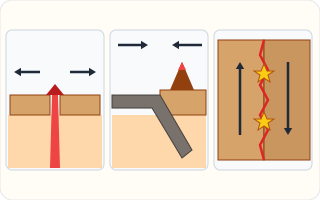
The plates move slowly, a few centimeters a year, about as fast as your fingernails grow. Where two plates meet, one of three things happens.
They pull apart. Hot rock rises into the gap, cools and makes new crust. There are volcanoes and small earthquakes. Iceland sits on such a boundary, the Mid-Atlantic Ridge, and the Atlantic widens by about 2.5 cm a year.
They push together. If one is an ocean plate, it is heavier and sinks under the other; deep down, rock melts and rises to make volcanoes, as in the Andes and the Cascades of Washington and Oregon, and the earthquakes can be huge. If both are continents, neither sinks, and the land crumples up into mountains: the Himalayas are still rising.
They slide past. The plates grind and catch, then jerk forward, causing earthquakes but no volcanoes, as along the San Andreas Fault in California.
Around the Pacific Ocean, boundaries of the second kind make a ring called the Ring of Fire, with about three-quarters of the world's active volcanoes and about nine in ten of its earthquakes.
Another way: diagram
Push two books together on a table and the covers buckle upward: that is two continents meeting. Slide one book under the other: an ocean plate sinking. Pull them apart and there is a gap to fill. Rub their edges past each other and they catch and jump: an earthquake.
Another way: steps
Left: plates pulling apart, with red melted rock rising into the gap. Middle: a gray ocean plate sinking under a brown continent, with a volcano on top. Right, seen from above: two blocks sliding past each other along a zigzag line, where the yellow stars mark earthquakes.
The Earth's outer shell, the crust and the rigid rock just beneath it, is broken into about a dozen large plates and many small ones. They fit together like the pieces of a cracked eggshell, but they are not still: they ride on hotter, softer rock below, which flows very slowly.
The North American plate carries most of the United States and the western half of the North Atlantic. The Pacific plate, the largest, lies under most of the Pacific Ocean, and California's coast sits on its edge.
Rocks on either side of the Mid-Atlantic Ridge get older the farther they are from it, which shows new crust forming at the ridge and spreading outward. The shapes of South America and Africa fit together, and the same fossils are found on both.
Today satellites measure the motion directly. Receivers of the Global Positioning System fixed to the ground show the plates moving a few centimeters each year, exactly as the rocks predicted.
Off the coast of Washington and Oregon, the small Juan de Fuca plate sinks beneath North America. As it sinks it melts rock deep below, and the magma rises to build the Cascade volcanoes: Mount Rainier, Mount Hood and Mount St. Helens.
The same boundary can produce enormous earthquakes. Scientists know from buried forests and Japanese records of a great wave that a huge earthquake struck there in the year 1700, and they expect another.
The San Andreas Fault runs about $800$ miles through California. West of it, the Pacific plate moves northwest past the North American plate at a few centimeters a year.
The plates do not slide smoothly. They lock together, strain builds for decades, and then they slip suddenly, as in San Francisco in 1906. That is why California has strong earthquakes but, along this fault, no volcanoes.
Some volcanoes are nowhere near a boundary. Under Hawaii, a column of very hot rock rises from deep in the Earth and melts through the middle of the Pacific plate.
The plate moves over the hot spot like paper over a candle. Each island forms over the hot spot and is then carried away northwest, which is why the Hawaiian islands get older toward the northwest. Yellowstone sits over another hot spot, under the North American plate.
Because an island forms over the hot spot and is then carried away, its age and its distance from the hot spot reveal the plate's speed. An island $500$ km away that is $5$ million years old moved $100$ km per million years.
A kilometer per million years is a tenth of a centimeter a year, so that plate moves about $10$ cm a year, one of the faster plates on Earth.
Checking an answer. Plates move centimeters a year, not meters. A rate times a time gives a distance; over millions of years small rates make oceans.
Volcanoes need melted rock, and rock melts where it is carried deep and hot, as a sinking plate is, or where pressure drops as plates pull apart. So the direction of motion predicts whether volcanoes can form.
Earthquakes happen wherever rock is stressed and slips, which is true at every kind of boundary. Dividing a distance by a time to find a speed is allowed because the plate's speed has been steady over millions of years.
Not every earthquake is at a boundary. In 1811 and 1812 a series of powerful earthquakes struck near New Madrid, Missouri, in the middle of the North American plate. They rang church bells in Boston and briefly made the Mississippi River flow backward.
Scientists think old weak zones deep in the crust, left from ancient rifts, can still slip under the stress that plate motion puts on the whole plate. Mid-plate earthquakes are rarer than boundary ones, but they happen.
Alaska lies on the Ring of Fire, where the Pacific plate sinks under North America. In 1964 it suffered the strongest earthquake ever recorded in the United States, magnitude $9.2$, which lifted and dropped the land by many feet.
Knowing where boundaries are lets people prepare. Building codes in California and Alaska require stronger buildings, and tsunami warning centers watch for earthquakes under the sea that could send waves across the Pacific.
The most common slip is saying every earthquake or every volcano is at a plate boundary, when hot spots and mid-plate earthquakes break that rule. Another is thinking plates move quickly; they move centimeters a year.
A third is thinking every boundary has volcanoes, when sliding boundaries and continent collisions have almost none. A fourth is confusing the steady slow motion with the sudden slip of an earthquake that releases years of strain.
On May 18, 1980, Mount St. Helens in Washington erupted. An earthquake loosened the north side of the mountain, which collapsed in the largest landslide ever recorded, and a sideways blast flattened forests for miles. Fifty-seven people died, and ash fell across eleven states.
The volcano is one of the Cascades, built because the Juan de Fuca plate is sinking beneath North America. For weeks before the eruption, scientists from the U.S. Geological Survey watched small earthquakes and a bulge swelling on the mountain's side, and officials closed the area around it, which saved many lives.
Mount St. Helens shows how knowing the kind of boundary helps predict danger. A sinking plate means volcanoes and earthquakes, so the whole Cascade range, from northern California to British Columbia, is watched closely today by instruments that measure shaking, swelling and gas.
In the 1906 San Francisco earthquake, the ground along the San Andreas Fault jumped sideways by as much as about six meters in a few seconds. Fences, roads and rows of trees that crossed the fault were broken and offset, one half shifted along the other.
Over the long run the Pacific plate slides past the North American plate at a few centimeters a year. For decades the plates stay locked and strain builds up; then they slip all at once, catching up in seconds on years of motion. The 1906 earthquake and the fires that followed destroyed much of San Francisco.
Today scientists measure the fault's slow creep and the strain around it with GPS receivers and satellites. California's building codes, school drills and an earthquake early-warning system that can send phone alerts seconds before shaking arrives all come from understanding what kind of boundary lies beneath the state.
Every earthquake happens at a plate boundary. Most do, but not all. The New Madrid earthquakes of 1811 and 1812 shook the middle of North America, and Hawaii's volcanoes sit in the middle of the Pacific plate, over a hot spot.
Plates move quickly. A few centimeters a year. The shaking of an earthquake is sudden, but it releases strain that built up over many years.
All boundaries have volcanoes. Sliding boundaries and continent-to-continent collisions have almost none.
The Juan de Fuca plate moves toward North America. Name the direction.
$\text{together}$
The plates converge.
Ask whether one can sink.
$\text{yes, the ocean plate}$
Ocean crust is denser.
Predict what happens deep down.
$\text{rock melts into magma}$
The sinking plate is carried deep.
Name the result.
$\text{volcanoes such as Mount St. Helens}$
And strong earthquakes too.
The Indian plate pushes north into the Eurasian plate. Name the direction.
$\text{together}$
Converging.
Ask whether one can sink.
$\text{no, both are continents}$
Too light to sink.
Predict what happens.
$\text{the land crumples upward}$
The world's highest mountains.
Predict the earthquakes there.
$\text{yes, strong ones}$
Every boundary shakes.
Predict the volcanoes there.
$\text{hardly any}$
No sinking, no melting.
An island formed over the Hawaiian hot spot is now $560$ km away. Record the distance.
$560\ \text{km}$
How far the plate carried it.
The island is about $7$ million years old. Record the time.
$7\ \text{million years}$
How long it took.
Divide distance by time.
$\dfrac{560}{7} = 80$
Kilometers per million years.
Convert to centimeters a year.
$80 \div 10 = 8\ \text{cm}$
A tenth of the first number.
Check against the known range.
$\text{a few to about ten cm a year}$
A sensible speed.
Say which way the island moved.
$\text{northwest}$
Older islands lie northwest.
Name the plates' motion.
$\text{sliding past each other}$
The Pacific plate moves northwest.
Ask whether anything sinks or opens.
$\text{no}$
So nothing melts.
Predict what to expect.
Match each real place to what the plates are doing there.
| two continents pushing together and crumpling upward | two plates sliding past each other | two plates pulling apart | an ocean plate sinking under a continent | |
|---|---|---|---|---|
| Iceland | ||||
| the Andes, in South America | ||||
| the Himalayas | ||||
| the San Andreas Fault, in California |
Complete the worked solution: suppose a Hawaiian island formed over the hot spot and has since been carried $450$ km away by the Pacific plate in $9$ million years. Find the plate's speed in kilometers per million years, in centimeters a year, and the meters it moves in ten thousand years.
Divide the distance by the age.
$\dfrac{\text{km}}{\text{millions of years}} =$ k
Kilometers per million years.
Turn it into centimeters a year.
$\text{that speed} \div \text{ten} =$ c
A kilometer is 100,000 cm; a million years is a million years.
Find the meters in ten thousand years.
$\text{cm a year} \times \text{a hundred} =$ m
Ten thousand years of centimeters, in meters.
Compare with something familiar.
$\text{about as fast as fingernails grow}$
Slow, but steady for millions of years.
Along the west coast of South America, the Nazca plate meets the South American plate. Put the steps that build the volcanoes of the Andes in order.
Number the steps in order (write the number in the box):
About nine out of every ten earthquakes happen around the edges of the Pacific Ocean, where plates meet. But in 1811 and 1812 huge earthquakes shook New Madrid, Missouri, in the middle of the North American plate. Which statement fits all of this?
The picture shows three kinds of plate boundary. The yellow stars mark earthquakes. Click the place where you would expect earthquakes but **no** volcanoes.
This task has no paper form; do it on a device.
For each kind of boundary, would you expect volcanoes? Would you expect earthquakes?
| Volcanoes? | Earthquakes? | |
|---|---|---|
| plates pulling apart | ||
| an ocean plate sinking under a continent | ||
| two continents pushing together | ||
| plates sliding past each other |
In the same picture, click the place where **new** crust is being made, as it is in Iceland.
This task has no paper form; do it on a device.
The Atlantic Ocean is getting wider by about $2.5$ cm a year, as the plates on either side of the Mid-Atlantic Ridge pull apart. By about how much will it widen in $28$ years?
Answer: unit: m / cm / mm
The islands of Hawaii are volcanoes, and they stand in the middle of the Pacific plate, thousands of miles from its edges. A student says: *all volcanoes are at plate boundaries.* What does Hawaii tell us about that rule?
Lesson test: one question per skill, one attempt each, no hints. Your answers are checked when you submit.
The Atlantic Ocean is getting wider by about $2.5$ cm a year, as the plates on either side of the Mid-Atlantic Ridge pull apart. By about how much will it widen in $20$ years?
Answer: unit: m / cm / mm
You can read a plate boundary. Tell somebody why the Andes have volcanoes and the Himalayas hardly any, and why Hawaii does not fit the usual pattern. Next: the biomes, and why climate decides what grows where.
23. Your turn: the San Andreas Fault, step 3
$\text{earthquakes, no volcanoes}$
Like San Francisco in 1906.