Back to the on-screen lesson ·
Sources, tributaries, confluences and mouths, and the drainage basin that gathers a whole area's rain into one river.
Paper packet. Every task here also exists on screen, where it is checked automatically; answers written on paper are not assessed by Nydus. When you are back at a device, enter your answers there.
You will name the parts of a river system, trace which way water flows through a real river network, add flows at confluences, and use a watershed to say which river a place drains into.
In the water cycle, rain falls on the land and some of it runs off toward the sea. This lesson follows that runoff. Everything it does comes from one rule you already know: water always flows downhill.
| Term | What it means |
|---|---|
| Source | Where a river begins, often a spring or a lake in the hills. |
| Mouth | Where a river ends, in the sea, a lake or a bigger river. |
| Tributary | A smaller river or stream that flows into a bigger one. |
| Confluence | The place where two rivers meet. |
| Drainage basin | All the land whose water drains into one river. |
| Watershed | The high ground at the edge of a drainage basin. |
| Discharge | How much water a river carries past a point each second. |
Look at a big river on a map and you will see it is not one line but a branching shape, like a tree lying on its side. Tiny streams join to make tributaries, and tributaries join the main river, which grows bigger at every confluence. So most of the water flowing past a city on a big river fell as rain far away, on hills the river never touches.
All the land whose rain ends up in one river is its drainage basin. The Mississippi's basin covers about 1.2 million square miles, about two fifths of the lower 48 states, and gathers water from 31 states and two Canadian provinces. The line around a basin follows the high ground: rain that lands on one side of a ridge flows into one river, and rain that lands a step away on the other side flows into another.
Another way: diagram
Hold your hand flat, palm down, with the fingers spread. Your fingers are tributaries, the back of your hand is the main river, and your wrist is the mouth. Everything that lands on your hand runs to your wrist; that whole hand is the basin.
Another way: steps
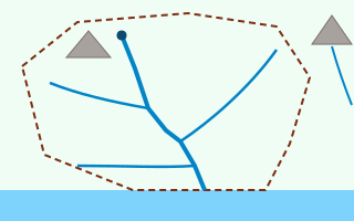
The thick line is the main river, from its source at the dark dot to its mouth at the sea. Three tributaries join it. The dashed line is the watershed: the hill inside it drains into this river, and the hill outside it drains away to the right.
| River | Length, about | Where it ends |
|---|---|---|
| Nile | 4,130 miles | the Mediterranean Sea |
| Amazon | 4,000 miles | the Atlantic Ocean |
| Mississippi | 2,340 miles | the Gulf of Mexico |
| Volga | 2,190 miles | the Caspian Sea, which has no outlet |
| Okavango | 1,000 miles | the Kalahari Desert, where it dries up |
The Mississippi begins as a small stream flowing out of Lake Itasca in northern Minnesota, narrow enough to step across on stones. It ends about $2340$ miles later in the Gulf of Mexico below New Orleans.
Along the way it gathers great tributaries. The Missouri joins just above St. Louis, the Ohio at Cairo, Illinois, and the Arkansas and Red Rivers farther south. By its mouth, most of its water has come from those tributaries, not from Lake Itasca.
A river's discharge is how much water flows past a point each second. At a confluence the discharges add: if a river carrying $100$ thousand cubic feet per second meets a tributary carrying $80$ thousand, the river below carries $180$ thousand.
That is why rivers grow as they go. The Ohio River carries more water than the Mississippi above their confluence, so below Cairo, Illinois, much of the Mississippi's water is really Ohio River water.
The edge of a drainage basin runs along ridges and high ground. On one side, rain drains into one river; on the other, into another. Americans often call the whole basin a watershed, while geographers also use the word for the edge itself.
The largest divide in North America is the Continental Divide, running along the Rocky Mountains. Rain to its west flows toward the Pacific; rain to its east flows toward the Gulf of Mexico or the Atlantic.
Some rivers end in lakes with no outlet, called inland basins. The Great Basin of Nevada and Utah drains inward: its rivers flow into lakes such as the Great Salt Lake, and the water escapes only by evaporating, leaving its salt behind.
Other rivers dry up in deserts before reaching any lake. The Okavango in southern Africa spreads into a maze of channels in the Kalahari and disappears into the air and the ground.
Rivers flow downhill, whichever direction that is. The Mississippi flows south, the Nile flows north, the Columbia flows west and the St. Lawrence flows northeast.
Maps put north at the top out of habit, not because north is uphill. To predict which way a river flows, find the high ground, where its sources are, and the low ground, where its mouth must be.
Checking an answer. A river's discharge never drops at a confluence; it grows. Water inside a watershed always reaches that basin's mouth, never another river's.
Water flows downhill because gravity pulls it, so every drop inside a basin must eventually reach the lowest point, the mouth. That is why drawing the watershed tells you exactly which river a raindrop will join.
Adding discharges at a confluence is allowed because the water in both channels goes on together. Nothing is lost at the join, so the flow below is the sum of the flows above.
A river carries whatever the water picks up: mud, sand, fallen leaves, and anything people put into it. Fertilizer from farms, oil from roads and waste from factories all travel downstream.
So a spill affects everything below it in the basin, and nothing above it. Cities take drinking water from upstream of their own drains for exactly this reason, and states along a river must work together to keep it clean.
Where a big river meets the sea it slows down and drops the mud and sand it has carried. Over centuries that sediment builds a delta, a fan of new land split by branching channels.
The Mississippi Delta in Louisiana was built this way over thousands of years. The Nile Delta in Egypt holds most of that country's farmland, because the river's mud is so fertile.
Cities grow along rivers for water, transport and power. St. Louis, Memphis and New Orleans grew along the Mississippi; Pittsburgh at the confluence where the Allegheny and Monongahela form the Ohio.
Barges still carry grain, coal and oil down the Mississippi, and dams along many rivers make electricity and store water. Understanding a river as a whole basin helps people manage it fairly for everyone who depends on it.
The most common slip is thinking a river's water comes from its source, when nearly all of it comes from rain across the basin. Another is thinking rivers flow south, or down the map.
A third is forgetting the land right beside the main river when adding up a basin. A fourth is thinking pollution can travel upstream or across a watershed into another river.
Every summer a large area of the Gulf of Mexico off Louisiana and Texas runs so low on oxygen that fish and shrimp leave or die. Scientists call it the dead zone, and in many years it covers several thousand square miles.
Its cause starts far upstream. Fertilizer spread on farms across Iowa, Illinois, Ohio and other states washes into streams, which flow into tributaries such as the Ohio and the Missouri, and on into the Mississippi. The river carries the nutrients to its mouth, where they feed huge blooms of algae. When the algae die and rot, they use up the oxygen in the water.
The dead zone shows why a drainage basin is a tool, not just a word. Everything inside the Mississippi's watershed, which covers most of the country's middle, drains to that one mouth. Shrinking the dead zone means changing how farms thousands of miles upstream use fertilizer, which is why federal and state agencies plan for the whole basin together.
In Glacier National Park, Montana, stands a mountain called Triple Divide Peak. Rain or melting snow on its summit can flow in three different directions and reach three different oceans.
Water running down one side enters rivers that reach the Pacific Ocean through the Columbia River. Water on another side flows into the Missouri, the Mississippi and the Gulf of Mexico, part of the Atlantic. Water on the third side flows north into rivers that reach Hudson Bay in Canada.
The peak sits where three great drainage basins meet, and it shows the watershed rule at its most dramatic. Three drops landing a few feet apart on the same summit end up thousands of miles from one another, each carried downhill through its own basin to its own mouth.
Every river flows directly from its source to the sea. Many flow into another river instead, and some never reach the sea at all: the Volga ends in the Caspian Sea, a lake with no outlet, and the Okavango dries up in a desert.
Rivers flow south, or down the map. They flow downhill, whichever way that is. The Nile flows north.
A river's water comes from its source. The spring at the source is tiny. Nearly all the water comes from rain across the whole basin, delivered by tributaries.
The White Nile flows north from the lakes of East Africa. Name its source area.
$\text{East African lakes}$
High ground.
The Blue Nile flows out of Lake Tana. Name that source.
$\text{Lake Tana, Ethiopia}$
A second source.
They meet at Khartoum. Name the place.
$\text{a confluence}$
After it, simply the Nile.
Follow the Nile to its mouth.
$\text{a delta on the Mediterranean}$
Downhill, which here means north.
The Mississippi carries about $110$ thousand cubic feet per second above the Missouri. Record it.
$110$
Thousand cubic feet per second.
The Missouri adds about $90$ thousand. Find the flow below.
$110 + 90 = 200$
Discharges add.
The Ohio adds about $280$ thousand at Cairo, Illinois. Find the flow below.
$200 + 280 = 480$
Discharges add again.
Find the share from the two tributaries.
$\dfrac{90 + 280}{480} \times 100 \approx 77\%$
Most of the water.
Say what that shows.
$\text{tributaries supply most of the water}$
Not the source.
Rain falls on a ridge between two valleys. Find the high ground.
$\text{the ridge}$
A watershed.
Follow a drop landing on the east side.
$\text{into the eastern valley}$
Downhill.
Follow a drop landing on the west side.
$\text{into the western valley}$
Downhill the other way.
Name each drop's river.
$\text{two different rivers}$
Separate basins.
Suppose the ridge is the Continental Divide. Name the two oceans.
$\text{Pacific and Gulf of Mexico}$
West and east.
State the rule.
$\text{the watershed decides the basin}$
Two drops a foot apart, two seas.
Name its source.
$\text{Lake Itasca, Minnesota}$
Where it begins.
Name its mouth.
$\text{the Gulf of Mexico}$
Below New Orleans.
Say where rain in its basin ends up.
Not every river ends in the same kind of place. Match each real river to where it ends.
| the Caspian Sea, a salt lake with no way out to the ocean | the Kalahari Desert, where its water spreads out and dries up | the Atlantic Ocean | the Black Sea | |
|---|---|---|---|---|
| the Amazon, in South America | ||||
| the Volga, in Russia | ||||
| the Danube, in Europe | ||||
| the Okavango, in southern Africa |
Complete the worked solution: a river carries $40$ thousand cubic feet of water per second before it meets its first tributary, which adds $25$ thousand. Farther down, a second tributary adds $15$ thousand. Find the flow after each confluence, and the percent of the final flow that came from the tributaries.
Add the first tributary.
$\text{river} + \text{first tributary} =$ s
Below the first confluence.
Add the second tributary.
$\text{that flow} + \text{second tributary} =$ t
Below the second confluence.
Find the tributaries' share.
$\dfrac{\text{both tributaries}}{\text{final flow}} \times 100 =$ p
Percent of the water at the mouth.
Say what the share shows.
$\text{much of a river's water comes from tributaries}$
Not from its source.
A raindrop lands on a hillside high up in a drainage basin. Put its journey to the sea in order.
Number the steps in order (write the number in the box):
The Nile starts in the highlands of East Africa and flows about 4,130 miles **north** to the Mediterranean Sea. Some people are surprised, because most maps have north at the top. Why does the Nile flow north?
This picture shows a river and its drainage basin from above. The thickest blue line is the main river, and the sea is along the bottom. Click the river's **mouth**.
This task has no paper form; do it on a device.
The Nile system: the Blue Nile flows out of Lake Tana in Ethiopia. The White Nile and the Blue Nile meet at Khartoum and become the Nile. Farther north, the Atbara River joins the Nile. The Nile then flows north to the Mediterranean Sea. Draw every *flows into* arrow.
This task has no paper form; do it on a device.
The dashed line on this picture is the edge of the river's drainage basin, called the watershed. Rain falls on both gray hills. Click the hill whose rain will end up flowing out of this river's mouth.
This task has no paper form; do it on a device.
A river has three tributaries. Their basins cover $12$, $30$ and $40$ thousand square miles. Another $19$ thousand square miles of land drains straight into the main river. How big is the river's whole drainage basin, in thousand square miles?
Answer:
A factory spills oil into a small tributary, just before it joins the main river halfway down its basin. Which of these places could the oil reach? Choose **every** one that could.
Lesson test: one question per skill, one attempt each, no hints. Your answers are checked when you submit.
A river has three tributaries. Their basins cover $13$, $34$ and $39$ thousand square miles. Another $14$ thousand square miles of land drains straight into the main river. How big is the river's whole drainage basin, in thousand square miles?
Answer:
You can read a river system. Tell somebody why the Nile flows north, and why two raindrops a foot apart can end up in different seas. Next: the rock that rivers, ice and wind wear away and carry off.
23. Your turn: the Mississippi's journey, step 3
$\text{at that mouth}$
Everything inside the watershed drains there.