Another way: diagram
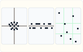
Left: nucleated, packed around a crossroads. Middle: linear, along one road. Right: dispersed, each house on its own.
Back to the on-screen lesson ·
Why settlements began where they did, how they grow, and the nucleated, linear and dispersed shapes they make on the map.
Paper packet. Every task here also exists on screen, where it is checked automatically; answers written on paper are not assessed by Nydus. When you are back at a device, enter your answers there.
You will explain why real settlements began on their sites, name the pattern a settlement makes, and follow how a village grows into a town or a city.
You know that people crowd where there is water, flat land and work. A settlement is where that crowding actually happens: one particular spot where somebody first built a house, and others followed.
| Term | What it means |
|---|---|
| Settlement | Any place where people live, from a single farm to a megacity. |
| Site | The land a settlement is built on. |
| Nucleated | Packed closely around a center, such as a crossroads or a square. |
| Linear | Stretched along a line, such as a road, river or valley. |
| Dispersed | Spread far apart, each building on its own land. |
| Settlement hierarchy | The ranking of settlements by size, from a farm to a megacity. |
Before cars and piped water, people chose sites very carefully. They needed water to drink, so many settlements grew by a spring or a river. They needed to be safe, so some chose hilltops or river forks that were easy to defend. They needed to travel and trade, so towns grew where a river could be crossed, where roads met, or beside a sheltered harbor. Some grew around a resource: coal, copper, salt, good farmland, or a waterfall to turn mill wheels.
Once a settlement starts, it can grow. A village with a market attracts people from the villages around it; a railroad or a factory brings jobs; more people bring more stores and schools, which bring more people again.
Seen from above, settlements make shapes. Nucleated settlements are packed around a crossroads, a square or a courthouse. Linear ones follow a road, a river or a narrow valley. Dispersed farms are spread across the countryside, each on its own land.
Another way: diagram
Left: nucleated, packed around a crossroads. Middle: linear, along one road. Right: dispersed, each house on its own.
Another way: steps
To explain where a settlement began, ask: 1. Was there water nearby? 2. Was the site easy to defend? 3. Could people cross a river, meet on roads, or land boats there? 4. Was there something valuable in the ground, the soil or the river?
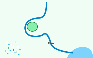
Four possible sites. The hill in the river loop is easy to defend. The row of stones marks a shallow place where the river can be crossed, a good spot for roads to meet. The bay is a sheltered harbor for boats. The marsh is low, wet and liable to flood: nobody's first choice.
Every settlement needs water, and before pipes and pumps it had to be close by. Springs, rivers and lakes decided where the first houses went.
Rivers gave more than drinking water. They carried boats and goods, and falling water could turn a mill wheel. Minneapolis grew at St. Anthony Falls, the only large waterfall on the Mississippi, where flour mills used the river's power.
When raids and wars were common, people chose sites that were hard to attack: hilltops, river loops and islands. A hill with water on three sides needed a wall on only one.
Pittsburgh began as Fort Pitt, built where the Allegheny and Monongahela Rivers join to form the Ohio. Whoever held the point of land between them controlled the river route into the west.
Towns grow where routes meet. A shallow place to ford a river, a bridge, a mountain pass or a crossroads funnels travelers through one spot, and some of them stop to trade.
Many American towns grew at river crossings and later at railroad junctions. Where two railroads crossed on the prairie, a town with stores, grain elevators and hotels often sprang up within a few years.
A deep, sheltered bay lets ships anchor safely out of storms, so it draws traders, fishing boats and later whole cities. San Francisco, Seattle and New York all grew around fine natural harbors.
New York's harbor, protected and deep, with the Hudson River reaching inland, made it the busiest port in the country, and its trade helped make it the largest city.
Some settlements grew because of what lay underground. Butte, Montana, grew on a hill so rich in copper that it was called the Richest Hill on Earth. Gold rushes built towns across California, Colorado and Alaska almost overnight.
Resource towns can shrink as quickly as they grow. When the ore runs out, the jobs leave, and some old mining towns in the West are now ghost towns.
The land shapes a settlement. In a narrow valley the only flat ground is beside the road and the river, so houses form a line. Where roads cross on open land, buildings cluster around the crossing.
On the prairies, the Homestead Act of 1862 gave families farms of $160$ acres, so each farmhouse sat on its own land, far from its neighbors: a dispersed pattern that still shows across the Great Plains.
Checking an answer. A growth total must include the houses a settlement started with, not only the new ones.
Early settlers had no pipes, cars or electricity, so a site had to offer what they needed within walking distance. That is why asking what a site offered explains where settlements began.
Adding the houses built each decade to the starting houses is allowed because houses stay once built. The total grows by the same amount each decade, so multiplying by the number of decades gives the new houses.
The reason a town started is not always the reason it is big today. Pittsburgh's fort made it important in the 1700s; its steel mills made it huge in the 1900s; its universities and hospitals keep it going now.
Growth feeds itself. More people means more stores, schools and jobs, which draws still more people. Geographers place the larger settlements near the top of the settlement hierarchy, because they offer services the smaller ones cannot.
Settlements can be ranked from smallest to largest: a single farm, a hamlet, a village, a town, a city and a megacity of more than $10$ million people.
There are many more small settlements than large ones. People travel from villages to towns for groceries and high schools, and from towns to cities for hospitals, airports and major league games. Each level serves the ones below it.
The most common slip is thinking every settlement grew for the same reason. Ask what each site offered: water, defense, a crossing, a harbor or a resource.
Another is thinking the reason a town started is why it is big today. A third is treating a settlement's shape as random, when the land and the routes shape it. A fourth is forgetting the starting houses when adding up growth.
St. Anthony Falls is the only major waterfall on the whole Mississippi River. In the 1800s its falling water was a source of power that no other spot on the river could offer, and sawmills and then flour mills crowded around it.
Wheat from the farms of Minnesota and the Dakotas came by railroad to be ground at the falls, and by the 1880s Minneapolis was the flour-milling capital of the world. Companies whose names are still on grocery shelves began there. The mills needed workers, the workers needed homes and stores, and a city of hundreds of thousands grew up around the falls.
Today the old mills are museums, apartments and parks, and the city's jobs are in health care, finance and offices. Minneapolis shows the whole story of a settlement: a site with something special, a resource that drew people, and growth that carried on long after the first reason faded.
When railroads crossed the Great Plains in the late 1800s, they created towns as they went. Trains needed water and fuel every so many miles, and railroad companies laid out towns at those stops, often with the station at the center and a grid of streets around it.
Across Kansas, Nebraska and the Dakotas, many towns sit a similar distance apart along the tracks, like beads on a string. Farmers brought grain to elevators beside the railroad, and stores, banks and churches grew up near the station.
Later, when highways replaced trains and farms grew larger with fewer workers, many of these towns shrank. Their pattern on the map still records why they began: a line of settlements following a line of track.
All settlements grow for the same reason. Minneapolis began at a waterfall, Pittsburgh at a fort where rivers meet, San Francisco at a harbor and Butte at a mine. Ask what each site offered.
The reason a town started is the reason it is big today. Pittsburgh's fort made it important long ago; its hospitals and universities keep it going now.
A settlement's shape is random. Shapes follow the land and the routes: a valley makes a line, a crossroads makes a cluster.
Two rivers meet at a point of land. Name them.
$\text{Allegheny and Monongahela}$
They form the Ohio.
Say what the point controlled.
$\text{the river route west}$
Boats had to pass it.
Name what was built there.
$\text{Fort Pitt}$
Defense of the forks.
Say what grew it later.
$\text{river trade, then steel}$
The site started it.
In a Colorado mountain valley, houses stretch a mile along one road. Look at the shape.
$\text{a long line}$
Not a cluster.
Ask what the land allows.
$\text{flat ground only by the river}$
Steep slopes on each side.
Ask what the road does.
$\text{follows the valley floor}$
Houses follow the road.
Name the pattern.
$\text{linear}$
Strung along a line.
Predict what a wide plain would do.
$\text{a cluster at a crossroads}$
Nucleated.
A village has $40$ houses when the railroad arrives. Record the start.
$40$
Houses before the railroad.
It adds $12$ houses each decade for $5$ decades. Find the new houses.
$12 \times 5 = 60$
Built after the railroad.
Find the total houses.
$40 + 60 = 100$
Start plus new.
Each house holds about $4$ people. Find the people.
$100 \times 4 = 400$
About four hundred.
Name the factor that drove it.
$\text{the railroad, a human factor}$
Trade and travel.
Place it in the hierarchy.
$\text{a village becoming a small town}$
Growing a level.
Name what the site offered.
$\text{a deep, sheltered bay}$
A safe harbor.
Say what the harbor allowed.
Say what grew the city.
Match each real American city to the reason it began where it did.
| a fort where two rivers meet to form a larger one | rich copper under the ground | a deep, sheltered bay for ships | a waterfall that could power mills | |
|---|---|---|---|---|
| Minneapolis, Minnesota | ||||
| Pittsburgh, Pennsylvania | ||||
| San Francisco, California | ||||
| Butte, Montana |
Complete the worked solution: a prairie village had $50$ houses when the railroad arrived. After that, $10$ houses were built every ten years for $7$ decades, and each house held about $5$ people. Find the new houses, the total houses at the end, and about how many people lived there.
Find the new houses.
$\text{houses a decade} \times \text{decades} =$ n
Built after the railroad came.
Add the houses it started with.
$\text{start} + \text{new} =$ h
All the houses.
Multiply by the people in each house.
$\text{houses} \times \text{people each} =$ t
About how many live there.
Name the kind of factor.
$\text{the railroad, a human factor}$
It turned a village into a growing town.
Put these kinds of settlement in order of size, from smallest to largest.
Number the steps in order (write the number in the box):
Kiruna, a town of about 20,000 people, is in the far north of Sweden, north of the Arctic Circle, where winters are long, dark and very cold. It is not on a big river or the sea. Why did a town grow there?
Three pieces of countryside seen from above, with small squares for houses. Click the one that shows a **linear** settlement.
This task has no paper form; do it on a device.
Long ago, a group of people wanted to build a settlement that enemies would find hard to attack. Click the site they should choose.
This task has no paper form; do it on a device.
Name the pattern each settlement makes: nucleated, linear or dispersed.
| Pattern | |
|---|---|
| houses in a row along a road in a narrow mountain valley | |
| farms spread across the prairies, each in the middle of its own fields | |
| houses packed around a crossroads and a town square | |
| fishing houses along a thin strip of coast between cliffs and sea | |
| houses crowded on a hilltop inside old town walls |
In 1900 a village had $57$ houses. After a railroad station opened, $5$ new houses were built every ten years. How many houses did it have in 1950?
Answer:
Chicago began where the Chicago River meets Lake Michigan, close to a short overland path to rivers that flow to the Mississippi. Put the stages of its growth in order.
Number the steps in order (write the number in the box):
Lesson test: one question per skill, one attempt each, no hints. Your answers are checked when you submit.
In 1900 a village had $35$ houses. After a railroad station opened, $9$ new houses were built every ten years. How many houses did it have in 1950?
Answer:
You can explain a settlement's site and shape. Tell somebody why Minneapolis, Pittsburgh and Butte each started where they did. Next: what a city does for the people and places around it.
23. Your turn: San Francisco, step 2
$\text{ships landing people and goods}$
Trade by sea.
23. Your turn: San Francisco, step 3
$\text{trade and the Gold Rush}$
The site started it.