Back to the on-screen lesson ·
Rivers cut down in their steep upper course, swing in meanders in the middle, and build floodplains, levees and deltas near the sea, at rates that can be measured.
Paper packet. Every task here also exists on screen, where it is checked automatically; answers written on paper are not assessed by Nydus. When you are back at a device, enter your answers there.
By the end of this lesson you will be able to explain how river landforms form and use rates, gradients and sinuosity to measure and predict change.
You know that rivers carry water from their sources to the sea, and you can read gradient and cross-sections from a map. This lesson follows a river from source to mouth and asks what it does to the land at each stage, and how fast.
| Term | What it means |
|---|---|
| Erosion | The wearing away and removal of rock and soil by moving water, ice or wind. |
| Deposition | The dropping of sediment when moving water slows down. |
| Long profile | A river's height plotted against distance from its source. |
| Meander | A sweeping bend in a river's channel. |
| Oxbow lake | A curved lake left when a river cuts off a meander loop. |
| Sinuosity | A river's channel length divided by the straight-line distance. |
A river does three jobs, and which one dominates changes from source to mouth.
The long profile shows the change: steep near the source, flattening toward the sea. Its gradient, meters of drop per kilometer, falls downstream.
Another way: picture
Picture a mountain stream racing over boulders in a narrow gorge, then the same water hundreds of miles later, wide and brown, sliding past levees toward the sea. The fast stream has energy to cut down; the slow river has only enough to carry fine mud, and drops it wherever it slows.
Another way: steps
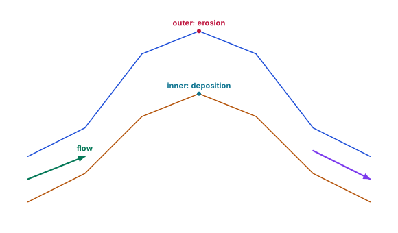
Follow flow from left to right around the bend. At its apex, the upper line is the outer bank and the lower line is the inner bank. In this model, faster flow near the outer bank favors erosion while slower flow near the inner bank favors deposition. Both happen in one bend. The drawing gives no scale or retreat rate: it explains a mechanism, not a measured forecast. Real channels vary with discharge, bank material, vegetation and engineering. A lower-course river can erode banks as well as deposit sediment; position alone does not settle its sediment budget.
A glacier moves ice and embedded rock. Abrasion scrapes the bed; plucking removes blocks. Glacial valleys may have broad floors and steep sides, and ice can leave poorly sorted till containing fine particles and large stones together. Meltwater can rework that material into sorted stream deposits. A rounded grain is therefore not proof of an exclusively river-shaped history: landscapes retain evidence from several episodes.
Soil develops through weathering, organic inputs and water movement over time. Parent material, organisms, climate, relief and time influence its properties. A rooted surface horizon stores water and supports vegetation; removing vegetation can expose that horizon to runoff erosion. Sediment lost from a hillslope may be stored on a floodplain, carried to an estuary, or delivered to a beach. Dams and bank protection can interrupt this supply, so a coastal sediment shortage can begin inland.
Work an invented sediment budget over one season. A basin receives 50 tonnes from eroding soil and 30 from reworked glacial deposits; 60 leave the outlet. With no other sources or sinks, storage increases by 20 tonnes. That balance does not locate the storage: field evidence must distinguish a floodplain deposit from a reservoir. To interpret a system, name inputs, transfers, stores and outputs, and retain the timescale. A short flood measurement cannot establish a long-term coastal budget.
Snow accumulation adds mass; ablation removes it through processes such as melting and sublimation. Compare both over the same glacier area and year, expressed as water equivalent so snow and ice can be compared. In an invented land-terminating glacier, accumulation is 800 millimeters and ablation 1100: the balance is 800 - 1100 = -300 millimeters water equivalent. The glacier has lost stored mass. Its terminus need not retreat immediately, and ice can keep flowing downhill while the glacier loses mass. Neither flow direction nor one year's balance alone establishes a long-term climate trend.
Season matters: winter snowfall can be stored until summer melting supplies a river. A year with extra melt may temporarily release more stored water, but a smaller remaining glacier cannot sustain that release indefinitely. Do not equate total ablation with measured river flow: some losses are vapor, and water can be stored or routed elsewhere. Check river gauges and the catchment boundary.
Try a second year before reading on: accumulation is 1000 and ablation 850 millimeters water equivalent. Does the glacier still lose mass? The balance is +150: it gains mass that year. Across the two years with the same reference area, the net is -150. This distinguishes a temporary gain from recovery of all prior losses.
A soil profile has layers, or horizons. An organic-rich surface and roots can support pores through which water infiltrates; lower horizons can store or transmit that water. Texture, structure, depth, compaction and existing wetness all matter. Till is parent material, not a fully developed soil by itself. Soil formation includes additions of organic matter, losses, movement between horizons and transformation of minerals. Clearing and compaction may alter water movement much faster than a mature profile forms.
For a controlled fictional storm, each of two matched plots receives 40 millimeters of rain. The rooted plot infiltrates 30; the compacted bare plot infiltrates 10. Assume no evaporation, other inputs or surface storage during this short event. Runoff is therefore 10 versus 30 millimeters. Infiltration is not all permanent storage: if 12 millimeters then drain below the rooted plot's soil boundary and 4 below the bare plot's boundary, soil storage gains are 18 and 6. More rapid surface runoff can transport exposed soil into a river, but sediment availability and slope also affect erosion. These measured plots do not establish a universal runoff ratio for all vegetation types.
Pause and interpret: a reservoir receives 90 tonnes of that river's sediment in a season and retains 60. With no other inputs or stores between reservoir and coast, 30 tonnes reach the coast. If coastal waves and currents export 45 tonnes from the beach over that same interval and there are no other beach inputs, beach storage falls by 15 tonnes. Thus increased erosion inland can coexist with coastal sediment loss. Without those coastal export measurements, river delivery alone would not establish a shrinking beach. Predict what happens if retention falls to 30 with everything else fixed: delivery rises to 60 and the beach gains 15 tonnes. In a real investigation, test whether waves and other inputs really stayed fixed.
A typical river changes as it flows from its source to the sea.
| Course | Gradient | Main process | Landforms |
|---|---|---|---|
| upper | steep | erosion downward | V-shaped valleys, waterfalls |
| middle | moderate | erosion sideways | meanders, bluffs |
| lower | gentle | deposition | floodplains, levees, deltas |
Real rivers are messier than the table, but the pattern holds on most of them.
Rivers erode in several ways. Rocks and pebbles carried by the water grind against the bed and banks like sandpaper. The force of the water itself pries loose weak rock. Water dissolves some rocks, such as limestone. And the pebbles knock against each other, becoming smaller and rounder downstream.
The faster and deeper the water, and the more sediment it carries, the more it erodes. That is why most erosion happens during floods.
A waterfall often forms where a band of hard rock lies on top of softer rock. The river wears the soft rock away faster, undercutting the hard layer until it collapses, and the falls retreat upstream, leaving a gorge below.
Niagara Falls, on the border of New York and Ontario, has retreated about seven miles since the end of the last ice age, carving the Niagara Gorge. Engineers now control the flow over the falls, which has slowed their retreat greatly.
In its middle course a river swings from side to side. At each bend the fastest, deepest water swings to the outside, eroding the bank into a steep river cliff. On the inside, the water is slow and shallow and drops sediment, building a gently sloping point bar.
Because one bank erodes while the other builds, the whole bend slowly migrates across the valley floor, and the valley widens over time.
As two bends erode toward each other, the neck of land between them narrows. Eventually, often during a flood, the river cuts through the neck and takes the shorter path. Deposition seals the old loop off, leaving a curved oxbow lake.
If a neck is $120$ m wide and each side erodes $3$ m a year, it narrows $6$ m a year and could be cut through in about twenty years.
When a river floods, water spreads over the flat land beside it and slows down, dropping its sediment. Over thousands of years layers of silt build a wide, fertile floodplain.
The heaviest sediment drops first, right beside the channel, building low natural ridges called levees. People have built artificial levees on top of them along rivers such as the Mississippi to hold floodwater in the channel.
Where a river meets the sea or a lake, its water slows sharply and drops most of its load. If waves and currents cannot carry the sediment away, it builds a delta, new land that pushes out into the water.
The Mississippi delta in Louisiana was built over thousands of years by sediment from much of the middle of North America. Today it is losing land, partly because levees and dams trap sediment that used to rebuild it.
The long profile's gradient in meters per kilometer measures steepness along the river: $400$ m over $20$ km is $20$ m per km, an upper course; $30$ m over $150$ km is $0.2$ m per km, a lower course.
Sinuosity measures how much a river bends: its channel length divided by the straight-line distance. A straight channel scores $1$; a river is usually called meandering above about $1.5$.
Checking an answer. Gradients should fall downstream. Sinuosity cannot be below one, because a channel cannot be shorter than the straight line.
Multiplying a rate by years is allowed when erosion is roughly steady, which holds on average over many years even though floods do most of the work. Dividing a neck's width by its narrowing is allowed for the same reason.
Comparing gradients in meters per kilometer is allowed because every stretch is measured in the same units, so a bigger number always means a steeper stretch.
People settle on floodplains because the land is flat and fertile, and near rivers for water and transport. But rivers move: meanders migrate, oxbows form, and floods spread across the floodplain that the river built.
Engineers straighten channels, build levees and cut off bends to control rivers. Each change alters where the river erodes and deposits, sometimes with effects far downstream, a theme the rest of this unit returns to.
The most common slip is thinking a river only erodes, or erodes most where it is largest. Lower courses carry huge amounts of water but deposit more than they erode, because their gradient is so gentle.
Another is forgetting that both sides of a meander neck erode. A third is writing sinuosity upside down, giving a number below one.
Lake Chicot, in southeastern Arkansas, is the largest natural lake in the state, and it is an oxbow lake: a former loop of the Mississippi River, cut off hundreds of years ago when the river took a shorter path. It curves for about twenty miles through farmland and woods.
Oxbow lakes like it line the lower Mississippi valley, each marking where the river once flowed. Scientists read them like a history book: their shapes and the sediments on their floors record where the river meandered and when.
In the 1930s and 1940s the U.S. Army Corps of Engineers deliberately cut through more than a dozen necks on the lower Mississippi, shortening the river by well over a hundred miles to speed floodwater to the sea and ease navigation. Each cutoff did on purpose what the river does on its own, in a few years instead of centuries.
Niagara Falls formed at the end of the last ice age, about twelve thousand years ago, where the Niagara River flowed over a hard layer of dolostone lying on softer shale. The river wore the soft rock back beneath the hard cap, which broke off in great blocks, and the falls retreated upstream.
Over those thousands of years the falls have retreated about seven miles, leaving the deep Niagara Gorge below them. Before engineers stepped in, the Horseshoe Falls were retreating by as much as a meter or more in some years.
Today much of the river's water is diverted through tunnels to hydroelectric power plants, and engineers have strengthened the rock at the crest, so the falls retreat far more slowly. A rate that once reshaped the gorge in centuries now changes it only a little in a lifetime.
It is natural to picture a river as a force that only wears land away, and to think the biggest rivers erode most. But a river's energy depends on its gradient as well as its size: the huge, slow lower Mississippi deposits far more than it erodes, building its floodplain and delta.
Even within one bend a river does both: it erodes the outer bank while it deposits on the inner one. Ask where the water is fast and where it is slow.
An outer bank retreats $4$ m a year. Name the process.
$\text{erosion}$
Fast water on the outside of the bend.
Find the retreat in $15$ years.
$4 \times 15 = 60\ \text{m}$
Rate times years.
Say what the inner bank does meanwhile.
$\text{grows by deposition}$
A point bar builds.
Say what happens to the bend.
$\text{it migrates outward}$
Across the floodplain.
The upper course drops $600$ m over $25$ km. Find its gradient.
$\dfrac{600}{25} = 24\ \text{m per km}$
Steep.
The middle course drops $90$ m over $60$ km. Find its gradient.
$\dfrac{90}{60} = 1.5\ \text{m per km}$
Moderate.
The lower course drops $30$ m over $150$ km. Find its gradient.
$\dfrac{30}{150} = 0.2\ \text{m per km}$
Nearly flat.
Compare the three.
$24 > 1.5 > 0.2$
The profile flattens downstream.
Say what each stretch mainly does.
$\text{cut down, swing, deposit}$
Upper, middle, lower.
A meander neck is $200$ m wide and each side erodes $4$ m a year. Find the narrowing each year.
$2 \times 4 = 8\ \text{m}$
Both sides.
Write the width after $t$ years.
$200 - 8t$
Starting width minus narrowing.
Find when it reaches zero.
$\dfrac{200}{8} = 25\ \text{years}$
The cut-off.
Name what forms.
$\text{an oxbow lake}$
The loop is abandoned.
Find the river's shortening if the loop was $2$ km long and the new channel $200$ m.
$2000 - 200 = 1800\ \text{m}$
Shorter and steeper.
Say what a shorter channel does.
$\text{steepens and speeds the river}$
Same drop over less distance.
Write channel over straight line.
$\dfrac{18}{12}$
Sinuosity.
Evaluate the expression.
$1.5$
One and a half.
Judge the stretch.
The outer bank of a meander bend retreats about $1.5$ m a year as the river erodes it. About how far will it retreat in $20$ years?
Complete the worked solution: a meander's neck is $200$ m wide, and the river erodes each side of it by $4$ m a year. Find how much the neck narrows each year and how many years until the river cuts through it.
Find the narrowing each year.
$\text{two sides} \times \text{rate} =$ n
Meters a year.
Find the years to cut-off.
$\dfrac{\text{width}}{\text{narrowing}} =$ y
Until the neck is gone.
Name what forms.
$\text{an oxbow lake}$
The old loop is left behind.
Say why it is an estimate.
$\text{a flood can cut it sooner}$
Erosion is not steady.
Match each river landform to how it forms.
| a steep river cutting down into its bed | a band of hard rock lying over softer rock | a meander loop cut off from the main channel | sediment dropped where a river slows at the sea | |
|---|---|---|---|---|
| a V-shaped valley | ||||
| a waterfall | ||||
| an oxbow lake | ||||
| a delta |
For each landform, say which part of a river it usually forms in and whether it is mainly made by erosion or by deposition.
| Part of the river | Mainly made by | |
|---|---|---|
| a waterfall | ||
| a meander | ||
| a levee | ||
| a delta |
The neck of land between two bends of a meander is $150$ m wide, and the river erodes each side of it by about $5$ m a year. Write the neck's width, in meters, as a function of the years $t$ from now.
Answer:
Along one stretch of its long profile, a river drops $600$ m over $25$ km. What is its gradient there, in meters per kilometer?
Answer: m per km
Suppose a stretch of the lower Mississippi River in Louisiana winds $45$ river miles between two towns that are $30$ miles apart in a straight line. What is the stretch's sinuosity, its channel length over its straight-line length?
Answer:
In a fictional basin, a land-terminating glacier gains 900 millimeters water equivalent of snow and loses 1200 over one year. Matched plots on old till receive the same 50-millimeter storm: a rooted plot infiltrates 35 millimeters, but a cleared, compacted plot infiltrates 20. With no other storm-water losses or surface storage, the rest runs off. Over a comparable sediment-monitoring season, 6 tonnes reach a reservoir, 2 are retained, and the rest reaches the coast with no other sediment inputs or stores. Mark every supported sentence linking these mechanisms and retaining their inference limits.
This task has no paper form; do it on a device.
Lesson test: one question per skill, one attempt each, no hints. Your answers are checked when you submit.
The neck of land between two bends of a meander is $90$ m wide, and the river erodes each side of it by about $2.5$ m a year. Write the neck's width, in meters, as a function of the years $t$ from now.
Answer:
You can explain river landforms. Explain why a meander erodes one bank while it builds the other.
27. Your turn: a stretch of river winds $18$ km between points $12$ km apart. What is its sinuosity?, step 3
$\text{meandering}$
About the usual threshold.