Back to the on-screen lesson ·
Extending the grid below and left of zero, and what reflecting does to the signs.
Paper packet. Every task here also exists on screen, where it is checked automatically; answers written on paper are not assessed by Nydus. When you are back at a device, enter your answers there.
In this lesson the coordinate plane grows from one quadrant to four, so points can have negative coordinates. You plot and read points in all four quadrants, reflect them across the axes, and find distances between points that share a coordinate. Reflecting a point across an axis flips exactly one of its signs, which makes the whole grid make sense at once: the four quadrants are one quadrant and its mirror images.
In grade 5 you plotted points like (3, 5) on a grid: start at the origin, go across 3, then up 5. That grid had only one corner, where both numbers are zero or more. In the last lesson you met negative numbers and opposites on a number line that runs both ways. This lesson puts two of those two-way number lines together, and the grid grows to four times its size.
| Term | What it means |
|---|---|
| x-axis | The horizontal number line. Numbers grow to the right. |
| y-axis | The vertical number line. Numbers grow upward. |
| Origin | The point (0, 0), where the two axes cross. |
| Ordered pair | Two numbers in parentheses, such as $(-3, 7)$, that name a point. The order matters. |
| Coordinates | The two numbers of an ordered pair: first the x-coordinate (across), then the y-coordinate (up or down). |
| Quadrant | One of the four regions the axes cut the plane into, numbered I, II, III and IV counterclockwise from the top right. |
| Reflection | A flip across a line, like a mirror image. The image is the same distance from the line on the other side. |
Take a number line that runs both ways and lay it flat: that is the x-axis. Take a second one and stand it up through zero: that is the y-axis. They cross at the origin, (0, 0). Every point on the plane now has an address, an ordered pair $(x, y)$. The first number says how far to go left or right; the second says how far to go up or down.
Negative numbers simply mean the other direction. $(-4, 3)$ means 4 to the left and 3 up. $(2, -5)$ means 2 to the right and 5 down.
The axes cut the plane into four quadrants, numbered with Roman numerals counterclockwise from the top right. The signs of the coordinates tell you the quadrant at a glance:
| Quadrant | Where | Sign of x | Sign of y |
|---|---|---|---|
| I | top right | + | + |
| II | top left | − | + |
| III | bottom left | − | − |
| IV | bottom right | + | − |
A point with a zero coordinate, such as $(0, -6)$ or $(5, 0)$, sits on an axis and is in no quadrant.
Because each axis is a two-way number line, each axis is also a mirror. Reflecting a point across the x-axis keeps its x and swaps the sign of its y. Reflecting across the y-axis keeps y and swaps the sign of x. So the four quadrants are really one quadrant and its mirror images.
Another way: picture
Draw a plus sign, big, in the middle of graph paper: the two lines are the axes. Write I in the top right space, II top left, III bottom left and IV bottom right, going around like a clock hand turning backward. Plot $(3, 2)$ in I, then fold the paper along the x-axis: the point lands on $(3, -2)$ in IV. Fold along the y-axis instead and it lands on $(-3, 2)$ in II.
Another way: steps
To plot $(-5, -2)$, put your pencil on the origin. The first number is $-5$, so move 5 units left along the x-axis. The second number is $-2$, so from there move 2 units down. Mark the point. Both signs are negative, so it is in quadrant III.
To read a point that is already plotted, go the other way. From the point, look straight up or down to the x-axis: that number is x. Look straight across to the y-axis: that number is y. Write them in that order.
The order matters. $(-5, 2)$ and $(2, -5)$ are different points in different quadrants. A good habit is to say it in words: 'across first, then up or down.'
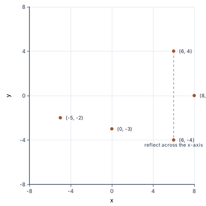
The chart marks the points from this lesson: one in each of three quadrants, a reflection across the x-axis, and two that sit on an axis and belong to no quadrant.
Some points have a zero in them. $(0, -3)$ means no move left or right and 3 down, so it sits on the y-axis, below the origin. $(8, 0)$ means 8 right and no move up or down, so it sits on the x-axis. Points like these lie on the borders between quadrants, so they belong to none of them. The origin, $(0, 0)$, is on both axes at once.
You can also compare two points without drawing them. The one with the smaller x is further left, and the one with the smaller y is further down. $(-7, 2)$ is left of $(-1, 2)$, because $-7 < -1$, even though 7 looks like the bigger number. $(4, -8)$ is below $(4, -3)$, because $-8 < -3$. This is the same ordering you used on a single number line, now used once for each axis.
Finally, points in the same quadrant always share both signs, and points in neighboring quadrants share exactly one sign. That is why a single reflection always moves a point into a neighboring quadrant.
A reflection across the x-axis flips a point from above the axis to below it, or from below to above. It does not move the point left or right, so x stays the same. The point ends up the same distance from the axis, so y keeps its size and changes its sign: $(6, 4) \to (6, -4)$.
A reflection across the y-axis flips a point from left to right. Now y stays the same and x changes sign: $(6, 4) \to (-6, 4)$.
An easy way to remember which one changes: the coordinate that changes is the one that measures distance from the mirror. Distance from the x-axis is measured up and down, by y. Reflecting across both axes, one after the other, changes both signs: $(6, 4) \to (-6, -4)$, from quadrant I to quadrant III.
When two points share one coordinate, they are on the same horizontal or vertical line, and the distance between them is easy to count.
Why add? The path passes through the axis. The first part runs from $-7$ to 0, which is 7 units, and the second runs from 0 to 4, which is 4 units. Subtracting $7 - 4 = 3$ would find the difference of the distances, not the length of the path. A quick sketch always tells you which case you are in.
Step 1: Read the signs. For each point, write down the sign of x and the sign of y. They tell you the quadrant before you draw anything.
Step 2: Plot across, then up or down. Start at the origin every time.
Step 3: For a reflection, find the mirror. Keep the coordinate along the mirror and change the sign of the other one.
Step 4: For a distance, find the shared coordinate. Then decide whether the two points are on the same side of the axis (subtract) or opposite sides (add).
Step 5: Check.
Most mistakes come from swapping the order of the coordinates, or from changing the wrong sign in a reflection.
Maps of the Earth use a giant coordinate grid. The equator plays the part of the x-axis and the prime meridian, which runs through Greenwich in London, plays the part of the y-axis. Longitude says how far east or west a place is, and latitude says how far north or south, both in degrees. If we count east and north as positive, every place on Earth is a point.
Denver, Colorado is at about 105 degrees west and 40 degrees north, so it is near $(-105, 40)$: quadrant II, like the rest of the lower 48 states. Sydney, Australia is at about 151 degrees east and 34 degrees south, near $(151, -34)$: quadrant IV. Buenos Aires, Argentina is near $(-58, -35)$, in quadrant III.
Notice that Sydney and Buenos Aires are almost the same distance south of the equator. Their latitudes are $-34$ and $-35$, only one degree apart, even though the two cities are on opposite sides of the world.
Chicago numbers its addresses from one corner downtown, where State Street crosses Madison Street. That corner is the origin. Addresses go up by about 800 for every mile you travel away from it, north, south, east or west.
Wrigley Field, where the Chicago Cubs play, is at 1060 West Addison Street, and Addison Street is 3600 North. Using miles as the unit, with east and north positive, Wrigley Field is at about $(-1060 \div 800, \; 3600 \div 800) = (-1.3, 4.5)$. That is quadrant II: about 1.3 miles west and 4.5 miles north of State and Madison.
The grid also tells you how far you must walk along the streets. From the origin, a walk to Wrigley Field is about $1.3 + 4.5 = 5.8$ miles, because you have to go west and north separately.
Swapping the coordinates. $(3, -1)$ means 3 across and 1 down. Plotting it as 1 across and 3 down gives a different point. Across comes first.
Numbering the quadrants the wrong way. They go counterclockwise from the top right: I, II, III, IV. Quadrant II is top left, not bottom right.
Changing the wrong sign in a reflection. Across the x-axis, y changes, not x. The coordinate that changes measures distance from the mirror.
Giving a point on an axis a quadrant. $(0, 7)$ is on the y-axis. It is in no quadrant.
Subtracting across an axis. From $(-6, 2)$ to $(3, 2)$ is $6 + 3 = 9$ units, not $6 - 3 = 3$. When the points are on opposite sides, add.
A negative distance. A distance is a count of units, so it is never negative, whichever point you start from.
Plot $(-4, 3)$. Start at the origin.
$(0, 0)$
Every point is found by moving from the origin.
Read the first coordinate and move along the x-axis.
$x = -4 \;\Rightarrow\; 4 \text{ left}$
A negative x means move left.
Read the second coordinate and move parallel to the y-axis.
$y = 3 \;\Rightarrow\; 3 \text{ up}$
A positive y means move up.
Mark the point and name the quadrant from the signs.
$(-, +) \;\Rightarrow\; \text{quadrant II}$
Left of the y-axis and above the x-axis is the top-left quadrant.
Check by reading the point back.
$\text{down to } x\text{-axis}: -4, \quad \text{across to } y\text{-axis}: 3$
Reading a point should give back the ordered pair you plotted.
Reflect $(5, -2)$ across the x-axis. Name what stays the same.
$x = 5 \text{ stays}$
The x-axis is horizontal, so flipping over it does not move the point left or right.
Change the sign of y.
$(5, -2) \to (5, 2)$
The point was 2 below the axis, so its image is 2 above it.
Check the distances from the mirror.
$2 \text{ below} \to 2 \text{ above}$
A reflection keeps the distance from the mirror line and changes the side.
Now reflect $(5, -2)$ across the y-axis. Keep y and change the sign of x.
$(5, -2) \to (-5, -2)$
The y-axis is vertical, so the point jumps from right to left.
Name the quadrants of the point and its two images.
$(5, -2): \text{IV}, \quad (5, 2): \text{I}, \quad (-5, -2): \text{III}$
Each reflection moves the point into a neighboring quadrant across the mirror.
Reflect across both axes, one after the other.
$(5, -2) \to (5, 2) \to (-5, 2)$
Two reflections change both signs, which lands in the opposite quadrant, II.
On a town map, one block is one unit. The school is at $(-3, 5)$ and the park at $(-3, -4)$. How far apart are they? Find the shared coordinate.
$x = -3 \text{ for both}$
The same x means both points are on one vertical line.
Decide whether they are on the same side of the x-axis.
$5 > 0, \qquad -4 < 0$
One is above and one is below, so the path crosses the axis.
Find the distance from the school down to the x-axis.
$5 \to 0: \; 5 \text{ blocks}$
The school is 5 units above the axis.
Find the distance from the x-axis down to the park.
$0 \to -4: \; 4 \text{ blocks}$
$-4$ is 4 units from zero.
Add the two parts.
$5 + 4 = 9 \text{ blocks}$
The path is one piece above the axis and one below, so the lengths add.
Check by subtracting the y-coordinates.
$5 - (-4) = 9$
The top value minus the bottom value also gives the length of a vertical segment.
Change blocks into miles, where a city block is about 0.1 mile.
$9 \times 0.1 = 0.9 \text{ mile}$
Each unit on the map stands for one block, so multiply the count by the length of one block.
Read the two signs.
$(-, -)$
Both coordinates are negative.
Name the quadrant.
$\text{quadrant III}$
Left of the y-axis and below the x-axis is the bottom left.
Reflect across the y-axis: keep y, change the sign of x.
The point (-9, 9) is reflected and lands on (-9, -9). Which line was the mirror?
Point A is (8, -7). Reflect A across the x-axis to get B, then reflect B across the y-axis to get C. Find the missing coordinates, and the lengths of AB and BC.
Reflect A across the x-axis: keep x and change the sign of y.
B = (8, by)
The x-axis is a horizontal mirror, so the point jumps straight up to the same distance above it.
Reflect B across the y-axis: keep y and change the sign of x.
C = (cx, same y as B)
The y-axis is a vertical mirror, so the point jumps straight across to the same distance on the left.
Find the length of AB, which crosses the x-axis.
$AB = (\text{A to the axis}) + (\text{axis to B}) =$ ab
A and B share their x, so AB is vertical, and each end is the same distance from the axis.
Find the length of BC, which crosses the y-axis.
$BC = (\text{C to the axis}) + (\text{axis to B}) =$ bc
B and C share their y, so BC is horizontal, and each end is the same distance from the y-axis.
Which quadrant is the point (3, 3) in? Write the quadrant number as a digit, 1 to 4 (quadrant II is 2).
(3, 3) is in quadrant n
The point P is (-9, -6). Reflect P across the x-axis, and then reflect the original P across the y-axis. Fill in the blanks.
Across the x-axis: (-9, p). Across the y-axis: (q, -6).
How far apart are the points (-8, -1) and (9, -1)?
The distance is answer units.
A town map puts the town square at (0, 0). East and north are positive, and one unit is one block. The post office is 9 blocks west and 6 blocks south of the square. Write its coordinates. The library is the reflection of the post office across Main Street, which runs north and south through the square. Write the library's coordinates.
The post office is at (px, py). The library is at (lx, ly).
A city map puts the corner of its two main streets at (0, 0), and one unit is one block. The library is at (-2, -2) and the school is at (6, 4). You can only walk along streets, which run east-west and north-south. How many blocks long is the shortest walk from the library to the school?
The walk is answer blocks long.
Lesson test: one question per skill, one attempt each, no hints. Your answers are checked when you submit.
A town map puts the town square at (0, 0). East and north are positive, and one unit is one block. The post office is 2 blocks west and 5 blocks south of the square. Write its coordinates. The library is the reflection of the post office across Main Street, which runs north and south through the square. Write the library's coordinates.
The post office is at (px, py). The library is at (lx, ly).
You can plot points in all four quadrants and reflect them. Without looking: reflect (3, −5) across the $y$-axis. Which sign changed, and why that one?
16. Your turn: which quadrant is $(-2, -6)$ in, and where does it land when reflected across the y-axis?, step 3
$(-2, -6) \to (2, -6), \text{ in quadrant IV}$
The point jumps from 2 left of the y-axis to 2 right of it.